Introduction: Tackling the Transportation Tangle in 2026
The High Stakes of Event Traffic
Even a brilliantly executed event can be overshadowed by a chaotic arrival or departure. Attendees might forget a small hiccup during a show, but they won’t forget spending two hours stuck in a parking lot post-concert. Transportation is often the final touchpoint of an event experience, and if it turns into gridlock, all the positive impressions fade away. Surveys back this up – in a 2025 study of UK drivers, 84% reported parking or traffic stress that negatively impacted their enjoyment of events. In fact, over half of drivers have left events early to avoid traffic jams, and 72% say past parking nightmares have made them reconsider attending future shows. These stats highlight that solving the traffic puzzle isn’t just a nice-to-have – it’s essential for attendee satisfaction and even ticket sales.
How Technology Can Prevent Gridlock
Fortunately, 2026 offers event organizers a new arsenal of tech solutions to ensure the trip to and from the venue is as smooth as the event itself. We’re in an era where apps, AI, and data-driven tools can turn the dreaded end-of-show exodus into a manageable flow instead of a maddening jam. Forward-thinking venues and festivals are already proving it. Some are using parking reservation apps so attendees drive straight to an assigned spot without circling for ages. Others leverage AI-powered traffic predictions to adjust exit plans on the fly, or deploy smart navigation tools that guide fans to the best routes in real time. For example, one 50,000-person festival introduced an AI-driven routing system and cut average egress time by nearly 40% compared to previous years. Around the world, major events from mega-conferences in city centers to rural music festivals are finding that the right tech can sidestep gridlock and dramatically improve the fan experience.
A New Priority for Event Planners
Experienced event technologists know that transportation planning is now as critical as stage production or ticketing. In 2026, treating traffic management as an integral part of event planning is non-negotiable. The good news is that modern tools make it easier than ever to integrate transit into your event blueprint. Data connectivity and real-time communication mean you don’t have to rely on guesswork – you can adjust to conditions moment by moment. Meanwhile, AI and automation are doing heavy lifting, from predicting peak congestion times to directly controlling smart traffic lights. The following sections explore practical tech strategies that organizers can deploy today. We’ll delve into parking apps, live traffic monitoring, AI-driven routing, shuttle and rideshare tech, and more – with actionable tips and real-world examples. By the end, you’ll know how to harness these innovations so your attendees spend less time in gridlock and more time enjoying the event.
(Before diving in, remember that managing crowds outside your gates goes hand-in-hand with managing them inside. For insights on keeping onsite crowds safe and flowing, see how AI cameras and IoT crowd sensors are revolutionizing crowd management in live events. And if you’re running a massive event, learn why many organizers set up NASA-style event command centers to monitor every system and crowd movement in real time.)
Free Tool: Size Your Festival Site
Zoned capacity planning for arena, campsite, parking and entry lanes — against UK Purple Guide and NFPA density standards. Finds your bottleneck zone.
AI and Data-Driven Traffic Planning Before the Event
Learning from Past Events: Data as Your Base
Smart traffic management starts months before show day, with data-driven planning. The first step is mining historical data from past events – both your own and similar events elsewhere. Look at when attendees tended to arrive (Was there a big rush 30 minutes before show time? Did entry lines back up onto city streets?). Analyze how long it took to clear parking lots after the headliner finished, or which routes saw the worst jams. Modern event software and ticketing platforms can often provide insights like entry scan timestamps and parking pass usage rates. Even external data, like city traffic sensor logs or crowd-sourced traffic maps, can reveal patterns. With these inputs, planners can identify predictable choke points – for example, noticing that Lot C always fills first causing spillover on a specific road. By understanding these patterns, you can proactively change your plan – such as staggering parking lot openings or directing vehicles differently – rather than reacting blindly on event day.
AI Simulations and Predictive Modeling
Once you have some baseline data, AI-powered simulation tools can take planning to the next level. In 2026, advanced traffic modeling software (often using machine learning) lets you create a virtual model of your event’s traffic flow. You input variables like number of cars expected, arrival rates, local road networks, and even weather conditions, and the AI runs thousands of scenarios. The result is a prediction of where and when congestion is likely to occur. For instance, an AI simulation for a 40,000-attendee sports event might flag: “Expect a backup on Highway X off-ramp between 5:30–6:00 PM unless additional exit lanes or alternate routes are provided.” Armed with these predictions, organizers can make data-backed decisions – maybe adding a temporary lane with cones, opening gates earlier, or scheduling post-event fireworks to stagger departures. Some event operations teams also set trigger points based on AI forecasts: e.g., “If parking Lot A is 80% full and it’s only 5 PM, divert incoming cars to Lot B via Route Y.” Essentially, AI gives you a heads-up to implement contingency plans before a bottleneck fully materializes.
Ready to Sell Tickets?
Create professional event pages with built-in payment processing, marketing tools, and real-time analytics.
Integrating with City Traffic Systems
No event is an island – its traffic flows through public roads and neighborhoods. That’s why coordinating with city and regional traffic management is vital. Well ahead of the event, share your attendance numbers, timing, and maps of entrances/exits with local authorities. Cities appreciate being looped in – it allows them to adjust traffic signal timing, plan for police or traffic marshal deployment, and issue public advisories. In 2026, many cities are using Intelligent Transport Systems (ITS) that can be tuned for event days. If your city has a traffic operations center, consider setting up a direct line on event day so you can swap information in real time. For example, Los Angeles has been ramping up AI-driven traffic control in preparation for events like the 2026 World Cup and 2028 Olympics, where smart traffic lights will adapt in real time to surges in event traffic. Even on a smaller scale, your event can benefit from this trend. If the city can give priority “green waves” on key exit routes at the end of your show, it can flush vehicles out dramatically faster. In Orlando, a large theme park coordinates with the city to control interstate off-ramp lights when their nightly fireworks end – preventing backups onto the highway. Building these partnerships early ensures that your event’s traffic plan and the city’s infrastructure work in harmony rather than at odds.
Mapping and Navigation Data Feeds
Another pre-event tech tactic is leveraging mapping data providers to set up event-specific routing info. Navigation apps like Google Maps, Waze, Apple Maps and TomTom allow submissions of planned road closures, detours, or special routes for events. As an organizer, you can work with these companies (some have events portals or city partner programs) so that when attendees on their way pull up directions, they get steered along the best path. Waze’s Global Event Partner Program, for example, is a two-way data exchange partnership aimed at reducing event-day congestion by sharing real-time info. Organizers provide Waze with details of road closures, recommended routes, and lot locations; in return they gain access to Waze’s live traffic data and user reports during the event. By 2026, dozens of major events worldwide – from marathons to music festivals – use this kind of integration to literally put their traffic plan into drivers’ GPS apps. It means fewer attendees blindly following their same old route into a traffic jam, and more getting intelligent directions to the right entrance at the right time. If you can nudge even 20% of drivers to adjust their path to avoid a choke point (because their app told them to), that’s a huge win.
(For more on big-picture logistics preparation, including transportation coordination, check out the conference playbook on venue and logistics planning for 2026 events – it covers site selection, permits, and more tips for smooth execution. And if you’re organizing a festival, don’t miss our guide on managing festival traffic and road closures with local authorities to learn about permits, signage, and safety planning.)
Planning Timeline: Building a Traffic Tech Plan
To make all this concrete, here’s an example timeline for integrating smart traffic tech into your event planning:
Go Cashless With RFID Technology
Enable contactless payments, faster entry, and real-time spending analytics with RFID wristbands and NFC-enabled ticketing for your events.
| Timeline (Before Event) | Key Planning Steps for Traffic Management Tech |
|---|---|
| 6–12 Months Out | Data review & forecasting: Analyze past event traffic data and gather city input. Begin discussions with city traffic agencies and transit providers. Research tech tools (parking apps, sensors, etc.) that fit your event. |
| 3–6 Months Out | Tech selection & contracts: Choose parking reservation platform, traffic monitoring systems, and any app integrations. Coordinate with map providers (Google/Waze) about road closures. Secure any needed permits for shuttles or traffic control. |
| 1–2 Months Out | Simulation & dry runs: Use AI simulations to fine-tune plans. Perform on-site tests if possible (e.g., drive the routes at expected times). Finalize staffing for traffic control and test tech systems (apps, sensors, command center software). |
| 1–2 Weeks Out | Attendee communication: Send detailed “Know Before You Go” info to attendees (parking passes, transit options, maps). Ensure all integrations (navigation apps, city traffic center) are in sync for go-live. Set up your event Mission Control center with dashboards ready. |
| Event Day | Live monitoring & updates: Activate traffic command center early. Push real-time updates to attendees via apps/alerts if needed (e.g., redirecting to different lot). Coordinate continuously with city traffic control and on-site teams. Have contingencies on standby (e.g., tow trucks, extra shuttle trips). |
| Post-Event | Debrief & data analysis: Gather all data (entry/exit times, traffic speeds, attendee feedback). Determine what worked and what didn’t. Feed these insights into your next event’s planning cycle. |
By following a structured timeline like this, you embed technology into your traffic plan from the start, rather than scrambling for fixes at the last minute.
Smart Parking Management: Apps, Sensors & Fast Exits
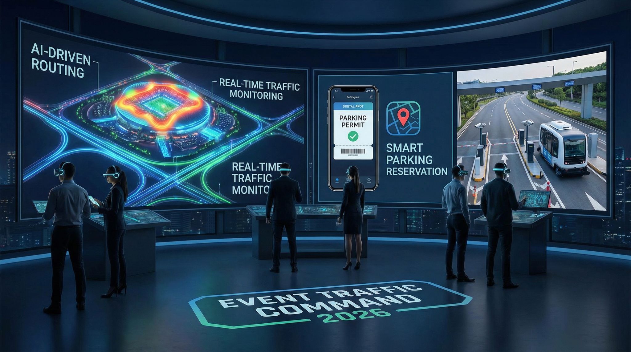
Advance Parking Reservations and Digital Permits
One of the most effective ways to prevent parking chaos is to take the spontaneity out of parking. Instead of attendees showing up en masse and paying on the spot (which often leads to long queues and uncertainty), events in 2026 are moving to pre-booked parking systems. With a parking reservation app or an online add-on during ticket purchase, attendees can select and pay for their parking in advance – sometimes even choosing a specific lot or space. This turns parking from a first-come, first-served scramble into an organized process. Drivers arrive with a digital parking permit (often a QR code on their phone or an RFID hangtag) and know exactly where they’re allowed to go. Not only does this cut down the decision-making at the gate, it also provides the organizer valuable data: you’ll know how many cars to expect and at which entrances, well before the show. Experienced promoters have found that when fans pre-pay for parking, they tend to arrive earlier and with less stress, smoothing out the peak entry surge. From a revenue standpoint, you can even sell premium parking tiers (e.g. closer lots or fast-exit lots) as an upsell, as many arenas and theme parks already do.
To illustrate the impact:
| Parking Approach | How It Works | Benefits | Challenges |
|---|---|---|---|
| Pay-on-arrival (traditional) | Cars arrive and pay cash/card at the gate, first-come basis. | Simple for attendees who decide last-minute. | Unpredictable turnout; causes backups at pay booths; no data on who’s coming. |
| Pre-paid reserved parking | Attendees book and pay for a spot or permit online before event. | Guaranteed spot for attendee; smoother entry with faster verification; data on arrivals for organizer. | Requires promotion so attendees know to book; needs a system to verify permits (QR codes/LPR). |
| Smart parking system | Pre-booking + tech like sensors and license plate recognition (LPR) at gates. | Fast, touchless entry (ANPR cameras scan plate); real-time lot occupancy tracking; optimal utilization of space. | Higher setup cost (equipment); must ensure tech reliability and have staff backup if tech fails. |
Many large events are adopting the pre-paid model with great success. For example, major concert venues in the UK and US now let you add a parking pass when buying your ticket online – shifting 70% or more of parking transactions to advance sales. This not only shortens the queue to enter the lot (since attendants aren’t handling payments), it can also increase safety (less cash on-site) and give the venue a chance to communicate parking instructions earlier. Some events mail out or allow download of color-coded parking permits (e.g., Lot Red, Lot Blue) so that drivers can follow specific signs corresponding to their permit. That leads to our next point: using tech to direct people once they’re on site.
Sensor-Guided Parking and Lot Monitoring
Ever circled a parking garage looking for an open spot? That frustration is amplified at events when thousands of cars are prowling lots and fields. Smart parking tech tackles this with sensor networks and real-time monitoring. Many modern parking facilities have sensors in each space or cameras with AI that detect occupancy. For outdoor festival lots (which might just be grass fields), you can use mobile CCTV trailers or even drones to monitor how lots are filling. The live data from these sensors and cameras feeds into dashboard software showing lot occupancy in real time. Parking managers can see, for example, that Lot A is 90% full while Lot B is only 50% – and make quick decisions to redirect incoming vehicles accordingly. Electronic signs at decision points (or push notifications to drivers) can then say “Lot A Full – proceed to Lot B via Elm Street”. This prevents the scenario of dozens of cars unnecessarily queueing for a lot that’s already full.
Some venues are also using smart guidance systems within multi-level parking structures: signs or lights that direct drivers to the nearest available spaces based on sensor input. At a large arena in Sydney, for instance, a system of green/red LED indicators above each bay plus pointer signs at intersections drastically reduced the time to find a space during events. On the simpler side, even a staff member with a tablet radioing to colleagues, “Lot C just filled, send incoming to D” – enabled by a bird’s-eye view from a drone or CCTV – is a tech-assisted improvement over waiting for chaos to ensue. The key is that in 2026, you don’t have to rely on guesswork or attendee patience. With affordable cameras and IoT sensors, you can know what’s happening across all parking areas in real time and guide the crowd accordingly. This integration of real-time data and responsive action is at the heart of smart traffic tech.
Smooth Entry With Mobile Check-In
Scan tickets and manage entry with our mobile check-in app. Supports photo ID verification, real-time capacity tracking, and multi-gate coordination.
Faster Entry and Exit: License Plate Recognition & Cashless Payments
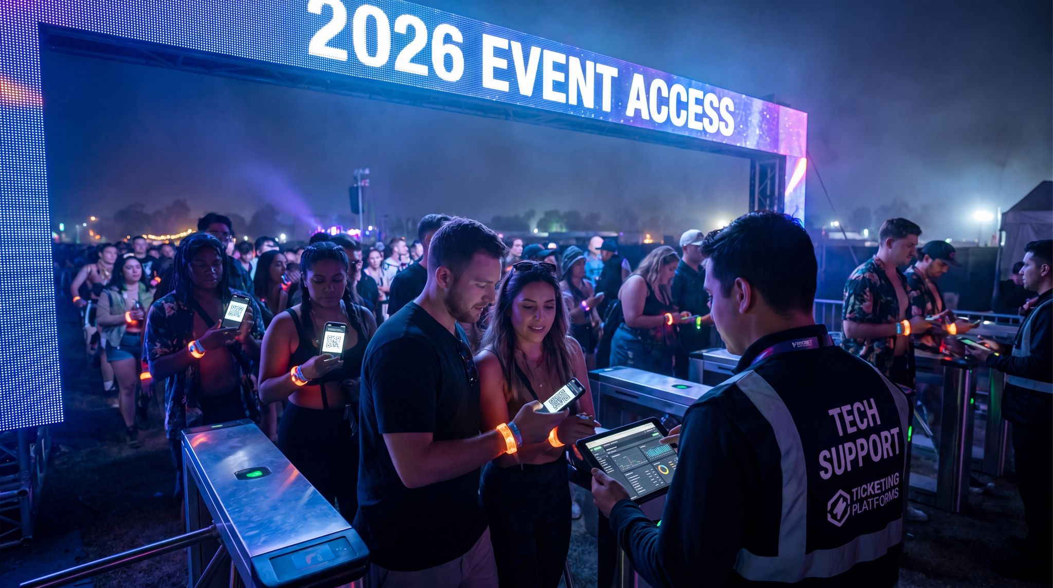
The moment of truth for any parking operation is at the choke points – the entrance gate and the exit bottleneck. Technology is attacking delays on both fronts. At entrances, License Plate Recognition (LPR) cameras (also known as ANPR – Automatic Number Plate Recognition) can be a game-changer. These systems automatically read vehicle plate numbers at entry, instantly checking them against your database of pre-booked permits or season passes. If there’s a match, the gate opens or an attendant waves the car through – no need to stop for a payment or even to scan a code. This creates an almost flow-through entry, perhaps only slowing down for a second instead of a 30-second transaction. LPR is already in use at many toll roads and shopping malls, and now events are catching on. For example, Festival Place in the UK introduced a barrierless parking system with autopay via license plate in 2025, so concert-goers just drive in and out without stopping, effectively reducing friction for fans and visitors. Such systems require upfront setup but can handle a high volume of cars with minimal staffing.
Where LPR isn’t feasible, QR code scanning of pre-paid parking passes is the next best thing – still much faster than handling cash or a credit card. Attendees either print a permit or have it on their phone; a quick scan validates entry. The trick is to have multiple scanning lanes or roving staff with handheld scanners to prevent a single line from forming. It’s worth noting that your choice of access control tech at parking gates should align with your overall event entry system. If your ticketing platform (like Ticket Fairy) offers built-in parking pass scanning integrated with the main ticket, use it – attendees could scan their concert ticket at the parking gate and be recognized if the system is unified. (Make sure to choose the right scanning technology for your scale – our detailed comparison of QR codes vs. RFID vs. biometric entry breaks down which methods process crowds fastest.) The bottom line: use tech that minimizes how often a car has to fully stop, whether that’s via automatic plate scans, tap-and-go payment, or waving an RFID parking pass.
Grow Your Events
Leverage referral marketing, social sharing incentives, and audience insights to sell more tickets.
Exiting after the show is another beast – often all cars want to leave at once, causing jams even inside the lots. One solution events use is exit codes or “fast lanes” for carpoolers or VIPs: for instance, a special QR code that gains access to an express exit route. Another approach is having staff stage the release of cars row by row (like how stadiums sometimes do one row at a time). Technology assists here by providing communication (push notifications that “Lot C, rows 1-5 may now depart”) and by coordinating traffic lights on the roads leading out. If you integrated with city traffic control, ensure those external intersections are giving more green time to exiting vehicles at peak egress. In summary, by using tools like LPR and pre-payment to speed up each car’s interaction and combining that with coordinated exit flow plans, you turn the parking lot from a stagnant mass into a steadily moving pipeline.
(For additional ideas on parking operations, see how venues are streamlining parking and traffic flow with tech and staffing optimizations in our in-depth guide. It covers lot layout design, staffing levels, and even how to handle speedy egress for pedestrians and vehicles in a tech-friendly way.)
Real-Time Traffic Monitoring and Control
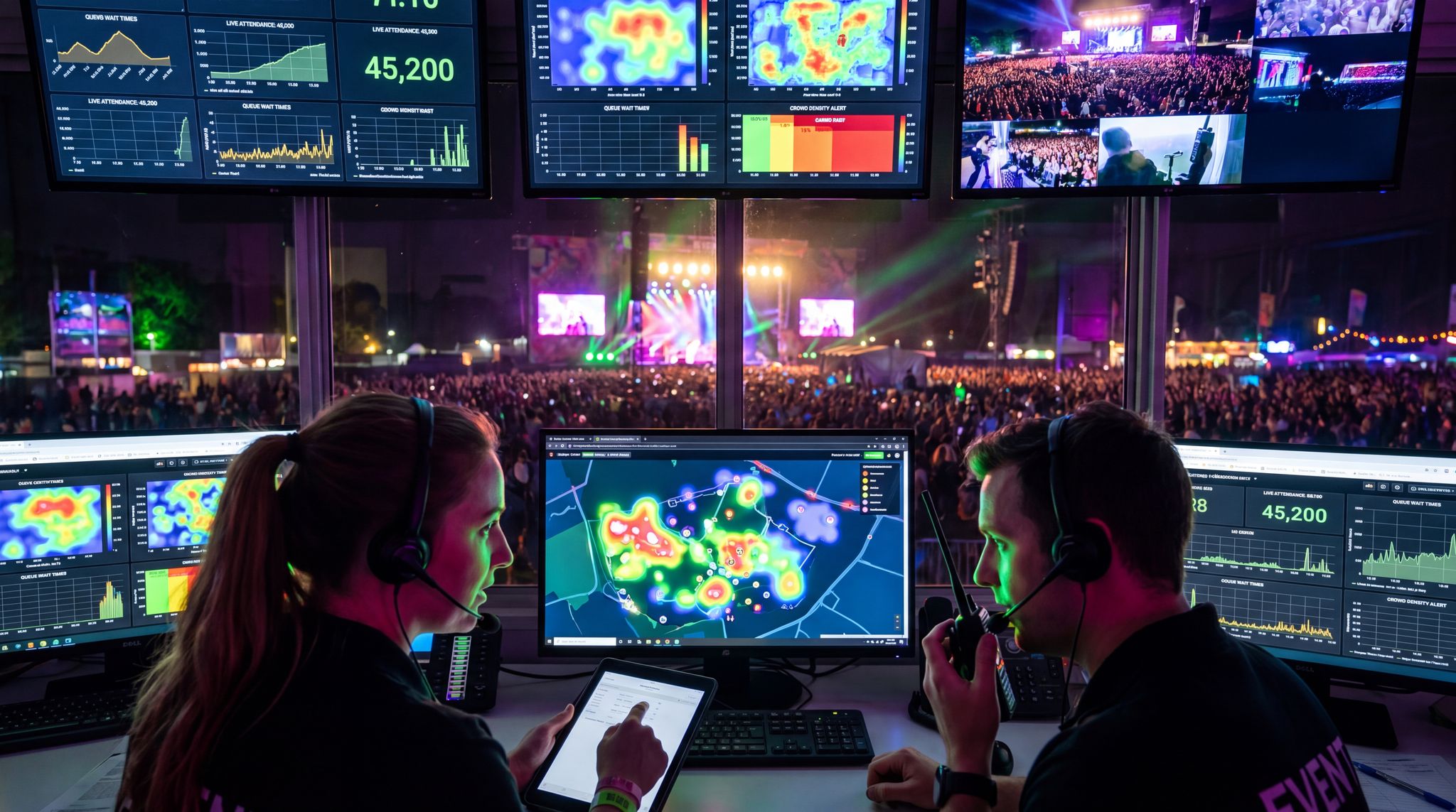
The Nerve Center: Live Traffic Command Centers
On event day, information is everything. That’s why large-scale events now often run a traffic “war room” – a central command center that monitors all aspects of ingress and egress in real time. Think of it as NASA Mission Control, but for your festival or stadium show. In this ops room, you might have multiple screens: some showing CCTV feeds from around the venue (entrances, nearby intersections, parking lots), others displaying maps with live traffic data (from services like Google Traffic, Waze, or TomTom), and perhaps a dashboard of stats like how many cars have entered per minute. Key staff from various teams sit together – parking managers, police or security liaisons, shuttle coordinators, and tech support. This setup enables rapid decision-making. If an incident pops up – say a fender bender blocks an exit lane – the team sees it on camera or gets an alert from a traffic app and can respond immediately (dispatching a tow truck, redirecting cars to another exit, etc.). Without a command center, that same incident might go unnoticed for 20 minutes while frustration builds.
You don’t need an army of people or an expensive control room to do this at an appropriate scale. For a festival of 20,000, it might simply be a couple of key operations folks in constant communication while watching a laptop with camera feeds and having a direct line to traffic marshals on the ground. The crucial factor is having a unified view of the situation. Many event professionals now integrate their traffic monitoring right alongside other event tech systems – the entry scans, the RFID tracking, the network status – as part of a holistic event command center. By doing so, your team can correlate data (e.g., “crowd entry slowed down, maybe parking is backed up outside”) and coordinate a unified response. If you’re new to this, start with a modest setup: maybe use a large room at the venue as HQ, and equip it with a mix of public data (like a live traffic map), any private feeds you have (cameras/drones), and open communication lines (radio or chat) with field staff. Practiced event ops teams swear by this approach – it’s much easier to keep 100,000 attendees moving like clockwork when you can see issues brewing in real time.
Boost Revenue With Smart Upsells
Sell merchandise, VIP upgrades, parking passes, and add-ons during checkout and via post-purchase emails. Increase average order value by up to 220%.
Eyes on the Ground (and in the Sky): Sensors, CCTV and Drones
To feed your command center with rich information, you’ll deploy a network of “eyes” watching the traffic. We’ve touched on parking lot sensors and cameras already; those feed into this system. Additionally, consider traffic counters or sensors at key approach roads – these could be temporary road tube counters or apps like Waze that tell you how many users are approaching from each direction. Many events collaborate with their city to get access to street CCTV cameras near the venue or highway security cameras. If that’s not available, installing a few mobile cameras on poles can cover the gaps. In recent years, drones have emerged as a powerful tool for overview monitoring. A drone flying 400 feet up can provide a live, birds-eye video of your entire parking field or the stretch of road leading to your gates. This aerial perspective is incredibly useful to spot developing congestion that ground cameras might miss (e.g., a backup forming 2 miles out). Some police departments will handle this with their own helicopters or drones (New York police have even used drones to watch over large gatherings), but organizers themselves can also hire licensed drone pilots to monitor traffic flow from above.
Another high-tech “eye” comes from the attendees’ smartphones. Aggregated, anonymized location data can show real-time heat maps of where people are coming from or if large numbers are stuck in one place. For instance, some event apps in 2026 offer opt-in location sharing specifically to help organizers see crowd movement patterns. In a traffic context, if a chunk of your audience is using the event app on the road, you might visualize that say 30% of them haven’t left home by 5 PM, so you expect a later rush – or that a cluster of them are inexplicably stopped near Gate 4, indicating a possible accident there. This bleeds into the realm of crowd management too, which is why crowd safety platforms and traffic management are increasingly linked. In fact, Glastonbury Festival (210,000 attendees) in 2023 employed a sophisticated integrated traffic management solution including mobile CCTV and ANPR cameras covering roads and entrances. The ANPR data helped track how many authorized vehicles had entered, and cameras let organizers and police visually confirm that traffic was flowing according to plan. By deploying a range of sensors and visual feeds, you create a rich picture that allows truly proactive control rather than reacting after getting 100 angry phone calls.
Adaptive Traffic Control and City Coordination in Real Time
Monitoring is half the battle – the other half is actively controlling traffic flow when needed. We’ve mentioned coordination with city traffic systems earlier for planning, but on event day this becomes a live dance. Adaptive traffic control means adjusting things like traffic light timings, reversible lanes, or police-directed intersections on the fly to respond to conditions. If your venue has a direct line to the city traffic center, use it: don’t hesitate to request “Hey, can you extend the green light an extra 20 seconds for the next 30 minutes on the main exit road? We have a wave of cars coming out now.” Many modern cities have computerized signal control that can implement such changes quickly, and some even have AI that will do it automatically when their sensors detect a surge (for example, some city systems can switch a boulevard to have three lanes outgoing and one lane incoming after a certain time to aid event egress). In Los Angeles, the DOT has tested an AI-based system that reads live traffic camera feeds and adjusts signals citywide – precisely the kind of tech that can benefit events with sudden traffic surges.
If you’re in a smaller town without that tech, old-fashioned methods still work – ensure you’ve arranged for traffic police or marshals at critical junctions with the authority to override signals or manually direct traffic when volumes spike. Equip these personnel with radios and feed them information from your command center. For instance, if your CCTV shows a parking lot is nearly emptying out, you might radio the officer at the next intersection: “In about 5 minutes you’ll see a big wave from Lot A, please hold the cross-traffic longer to let them all out.” Also, be prepared for contingencies: if an unforeseen road closure happens (maybe a car breakdown or, worst case, an accident), have a plan to redirect traffic along pre-identified alternate routes. Navigation apps will often automatically reroute drivers who use them, but you may need to guide those that don’t. This could involve putting temporary signs, sending push notifications (e.g., “Accident on Oak Street – use 5th Avenue to exit downtown”), and having staff at key forks to point people the right way.
One more emerging tool is vehicle-to-infrastructure (V2I) communication, where smart vehicles get live updates from road systems. While it’s not widespread yet, by 2026 some cars can receive real-time alerts in their dash about road conditions or suggested speed adjustments. Event organizers in tech-forward cities are starting to tap into this by getting their event listed on smart city platforms so that connected cars automatically get a heads-up like “Approaching X Event – expect slowdowns” or even guidance to specific parking lots if the system is integrated. We’re just at the dawn of this technology becoming common, but it’s worth noting for the future. For now, your best ally is a tight human and tech coordination loop: eyes on the data, people on the ground, and open channels between everyone managing the flow.
Rapid Incident Response
No matter how well you plan, things can go wrong – and when they do, a rapid response can mean the difference between a minor hiccup and a headline-grabbing debacle. Technology can assist in detecting and responding to traffic incidents faster. For detection, we already covered cameras and user reports (like when Waze users pin a road closure or accident). Ensure someone in your command center is actively watching for those alerts. Some advanced traffic management systems have automated incident detection, where an algorithm notices “speeds on segment D dropped below 5 mph abruptly” and flags it. Once an incident is confirmed – say a shuttle bus broke down on the main exit road – the key is communication and action. Have tow trucks or support vehicles pre-positioned if possible, and use navigation app alerts and attendee messaging to redirect others around the issue. In the shuttle example, you might temporarily route outgoing cars through an alternate gate until the blockage is cleared, and send an app notification: “Minor delay on Main Street exit, use South exit for faster egress.” Attendees greatly prefer being informed about a delay and given alternatives rather than sitting in mystery stagnation.
Data-Driven Event Marketing
Track ticket sales, demographics, marketing ROI, and social reach in real time. Exportable reports give you the insights to make smarter decisions.
From an operations standpoint, designate an “on-call strike team” for traffic issues. This could be a few staff or contractors ready to deploy to handle things like a damaged traffic light, a jammed parking lot exit, or even a pedestrian crowd spilling into a roadway. Equip them with the right tools: cones, barricades, maybe even portable traffic light units. A noteworthy example: Glastonbury’s 2023 traffic management included work-zone protection barriers and on-call teams as part of the integrated package, ensuring that if a route became unsafe or congested, they could quickly set up a new traffic pattern. Finally, loop back any incident into your data system – log the time and cause. These become lessons for the next event (e.g., “Lot D exit consistently jammed, next time assign an extra staff to wave cars or split them into two streams”). Tech won’t prevent every issue, but it will help you react decisively and transparently when Murphy’s Law strikes.
(Want a broader look at event crowd oversight? See how smart crowd management tools are helping organizers prevent bottlenecks and keep events safe – many principles overlap with traffic control, like using real-time dashboards and instant alerts to stay ahead of problems.)
AI-Powered Routing and Attendee Navigation
Integrating Event Plans into Navigation Apps
Attendees today heavily rely on their favorite navigation apps (Google Maps, Waze, Apple, etc.) to get them places – including your event. A savvy event organizer in 2026 makes sure those apps are on your side. We discussed feeding road closure info and ideal routes to mapping providers ahead of time; on the user end this translates to smarter routes. But integration can go deeper: some events partner with map apps for a sort of “white glove” experience. For instance, drivers heading to a Formula E race in 2025 were prompted in Waze with a special event icon and directions to official parking lots instead of random streets. If an attendee searched the venue name, the app steered them to the correct entrance based on real-time data (rather than the default main gate that might be overloaded). As an organizer, ensure that when people search for your event or venue in map apps, the pin and directions that come up reflect your traffic management plan.
One practical tip is to coordinate multiple “drop pins” for a single venue – one for each parking area or entrance – labeled appropriately. For example, Coachella might have separate map points for “Coachella Lot 1 – VIP Parking” vs “General Parking (follow green route)”. Your pre-event communications can include direct links to these pins (“click here for Google Map to Lot 1”). This way, attendees navigate to the right place on the first try. Nothing causes more traffic confusion than cars being told by GPS to go to the wrong gate and having to U-turn. Many navigation platforms will accommodate these nuances if provided by the event or city; they’d rather route users smoothly than contribute to a mess. Don’t forget smaller or regional map apps too if they’re popular in your country (for instance, in some countries, apps like Yandex Maps or Baidu Maps might dominate – make sure they get the memo on your event plans!). The goal is a seamless merge of your planning data with consumer navigation so that, as far as possible, every driver is a guided driver.
Personalized Route Recommendations and Staggered Arrival Times
Mass navigation is great, but what if you could give personalized travel advice to each attendee based on their situation? In 2026, data and AI make this feasible. Some ticketing systems now ask buyers for extra info like “Where are you coming from?” or “Are you driving or taking transit?” Especially for VIP packages or high-touch events like premium conferences, organizers might provide tailored guidance. For example, an attendee flying in for a convention might get an email: “We see you’re staying at the Downtown Hotel. We recommend taking the Light Rail to the venue – your event badge doubles as a transit pass for free rides.” Meanwhile, a local attendee from the north side might be told to use Entrance C and a specific route that avoids construction in the south. This kind of micro-segmentation uses mapping APIs and data about each attendee to pre-compute the best option for them. While doing this individually for thousands is challenging, even grouping attendees by zone or direction and sending customized instructions can make a difference (e.g., “Attendees coming from the west, please use Exit 24 off M4, then route via Newark St. to Parking Zone West”). It spreads out demand across entry points instead of everyone following the same mainstream route.
Another powerful approach is staggered arrival times encouraged through tech. If your event has some flexibility (like a festival with multiple stages or a conference with all-day programming), you can use incentives and information to avoid everyone arriving at once. The event app or ticket portal might allow attendees to choose an arrival window when they plan to get there, possibly with a small perk (“Arrive before 1 PM and get a free coffee token” or simply better parking location). This data then guides your predictions and also feeds what directions you send them. AI can help by analyzing how many selected each window and warning if one slot is overburdened. Some organizers go further and use dynamic messaging on the event day: if they see a huge surge en route, they might send a push notification to those who haven’t left yet saying “Traffic is heavy right now. If you haven’t started your journey, consider arriving a bit later – the opening act will be on until 8:00 PM and plenty of fun is happening on-site.” While not everyone will listen, such messaging can shave the peak down.
Smart Promo Codes & Presale Access
Create percentage or flat-rate discount codes with usage limits, date ranges, and ticket type restrictions. Plus unlock codes for private presales.
Geofencing and Dynamic Rerouting
Geofencing isn’t just for rideshare zones – it can be a versatile tool in traffic management. By setting up virtual perimeters (geofences) around certain areas, you can trigger automated actions or messages when users enter or exit those areas. For example, geofence the critical approach roads to your venue: as drivers enter that zone with the event app running, it could automatically pop up “Welcome to X Festival – Parking take next right for Lot B, left lane for drop-off.” This is like having dozens of dynamic road signs that appear on the users’ phones at exactly the right moment. Geofences can also be used to detect when attendees are nearing departure. A clever trick some events use: when a concert ends and people start walking to parking, the event app notices masses of users leaving the main stage area (via GPS) and proactively sends a traffic update: “Exit Tip: For fastest route to highway, use Gate 2 north exit. Traffic lighter towards north.” Essentially, using location data to adjust messaging in real time.
For drivers not using an event app, dynamic rerouting will rely on those navigation apps we talked about. Many cities and events push live updates to Waze or Google about changing conditions – for instance, if the south gate gets congested, they could update the system to route new incoming traffic to the north gate instead. Waze’s platform allows event partners to input such changes on the fly, so the AI routing engine redirects drivers around emerging bottlenecks. This is AI at work in a very tangible way: thousands of individual route suggestions quietly changing in the background to optimize overall flow. One must coordinate carefully; you wouldn’t want to bounce people around too frequently, causing confusion. But when used judiciously – say to split traffic between two exits once one gets saturated – it can reduce total clearance time. Imagine half your crowd automatically being navigated to an alternate route that takes 5 minutes longer but avoids a jam – that’s a huge load off the main artery. From the attendee perspective, it just feels like their GPS found a better way; from the bird’s-eye view, you orchestrated a symphony of paths to prevent one big jam.
Beyond simple navigation, forward-thinking organizers are asking: are there any tools that offer geofencing marketing campaigns to manage parking demand dynamically and integrate with public transit systems? The answer in 2026 is a resounding yes. Modern event management platforms and specialized transit apps allow promoters to trigger location-based promotional messages. For example, if your primary lots are nearing capacity, a geofenced campaign can automatically ping approaching attendees with an offer: “Park at the downtown transit hub instead, ride the light rail in for free, and get a $10 food voucher.” This seamlessly blends marketing incentives with traffic control, dynamically shifting vehicle load away from congested venue gates and onto high-capacity public transit networks.
Multi-Modal Route Planning (Car, Train, or Bike?)
Not everyone will drive a car to your event, and routing tech should cater to all modes. In modern event apps or communication, it’s smart to offer multi-modal journey planning – especially for urban events. Some attendees might drive to a park-and-ride, then take a shuttle bus; others might take a train then walk; still others might use a bicycle or scooter for that last mile. AI route planning can now incorporate these mixed modes. For example, an app could suggest: “Drive to City Lot XYZ, park there (you have a reservation), then hop on the event shuttle bus which will be there in 10 minutes – you’ll arrive at the gate by 7:45 PM.” This is actually something some European festivals have refined: Tomorrowland in Belgium offers a plethora of travel options on their website and app, including recommended train routes from Brussels and then shuttle transfers. By providing integrated directions (with maps, schedules, and purchase links if needed), you remove friction for attendees to choose those alternatives over driving the whole way.
In 2026, with sustainability goals rising, many events actively promote carpooling and cycling too. There are apps that facilitate carpool matching for events – connecting attendees from the same area to share rides. If you integrate that or simply encourage it, navigation can reward carpoolers with special routes (e.g., a HOV lane into the venue for vehicles with 4+ people, just like some cities do on highways). As for cycling or scooters, ensure your mapping includes bike-friendly routes and the location of bike parking or scooter drop zones. Some city events geofence scooter drop-off to certain areas to keep entrance gates clear. All these details can be communicated via route planning tools so that regardless of whether someone is driving, taking a train, or riding a bike, they get clear, optimized guidance tailored to their mode of travel. The payoff is a smoother arrival for them and fewer cars on the road for you.
(Curious about how all your event tech systems connect? Read about developing a cohesive event tech stack that links ticketing, access, and even transit data for seamless operations. Integration is the secret sauce to have ticket scans, parking, and traffic info all feeding into one view.)
Enhancing Shuttle Services and Public Transit Integration
Dedicated Shuttle Buses and Park-and-Ride Programs
For large events, one proven method to cut down traffic is to provide shuttle buses or park-and-ride services. Instead of 5,000 individual cars all converging on the venue, you operate, say, 100 buses that each carry 50 people from key locations. It’s more efficient and can dramatically reduce congestion – if people actually use it. The technology tie-in is making shuttles convenient and visible to attendees. First, planning: identify pickup/drop-off hubs (like major parking lots on the city outskirts, or transit stations) and coordinate with those facilities. Many festivals partner with shopping mall parking lots or university campuses on weekends to use their lots for park-and-ride.
Next, ticketing and booking: use your event website or app to allow attendees to reserve shuttle spots or purchase shuttle passes easily. Some events include shuttle passes as add-ons during ticket checkout (much like parking passes). If you can gauge demand per location in advance, you’ll know how many buses to allocate. In 2026, we also see dynamic shuttle routing – smaller shuttles that can change route based on demand, almost like an Uber Pool but with vans. For example, a tech conference in San Francisco used an app where attendees could request a shuttle pickup from a list of spots, and an AI dispatcher routed vans accordingly rather than fixed routes. This kind of flexibility can increase uptake because it adapts to where people actually are.
From an operational standpoint, make sure to advertise the time savings of shuttles. If taking the shuttle means you get to use a priority bus lane and skip the general traffic queue, tell attendees that. Events in cities like Singapore and London coordinate with local authorities so that event shuttles can use special lanes or get police escorts – significantly reducing travel time. When attendees see “shuttle gets you there 15 minutes faster than driving,” they’re more inclined to hop on board.
Real-Time Shuttle Tracking for Attendees
Nobody likes waiting in uncertainty. If you offer shuttles, implement a shuttle tracking system that lets attendees see where the next bus is and its ETA. This is one of those tech features that dramatically improves user experience with minimal cost. Many transit apps or white-label shuttle apps are available: they equip each bus with a GPS tracker (even a smartphone with the driver can suffice) and publish its live location to a simple map that users access via the event app or a web link. Attendees can then wait comfortably (“Ah, the next bus from Downtown is 5 minutes away, it’s just two blocks down according to the map”) rather than anxiously wondering if they missed it. For example, Coachella has long offered shuttle services from various cities and posts the schedules, but in recent years they also added real-time tracking through their mobile app so festival-goers could plan exactly when to leave their hotel.
Shuttle tracking isn’t just about convenience – it increases trust and usage. People are more likely to opt for a shuttle if they know they won’t be stranded. Operationally, it also reduces overcrowding at bus stops because if folks see a bus is 15 minutes away, they might wait indoors a bit longer instead of flocking to the curb all at once. Some systems also allow push notifications or text alerts (e.g., “Your shuttle is 2 minutes away, look for bus #7”). As an organizer, you can monitor all shuttle positions on a dashboard, which helps in making any necessary adjustments (like if one route is lagging, you could send an extra bus). In essence, shuttle tracking brings the kind of visibility people expect from ride-hailing apps to your event transportation. It’s the norm in public transit in many cities, so attendees will appreciate the same transparency in event shuttles.
Coordinating with Public Transit and Trains
Your event shouldn’t exist in a transportation vacuum – if there’s a public transit network in your area, embrace it as part of the solution. Large conferences and stadium events in big cities often see a majority of attendees arrive via trains, subways, or trams, provided those options are available and well-promoted. Work closely with the local transit authority to do a few key things: extend service hours, add capacity, and offer integrated ticketing. If your concert might end at 11:30 PM but the last train usually leaves downtown at midnight, see if they can run an extra late train or two. Many transit agencies will do this for major events if asked and if costs are covered (sometimes the city or event organizer sponsors the extra service). Also, if you expect a surge, they might add extra carriages or run back-to-back departures to move more people. Sporting events and festivals in cities like New York, London, and Tokyo do this routinely – for instance, after a big football match in London, you’ll see trains queued up at the nearest Tube station ready to load crowds.
Next, make it easy for attendees to use transit. In some cities, event tickets double as transit passes – a concept known as “free transit with event ticket” which both incentivizes public transport and speeds up boarding since people aren’t fumbling to buy fares. The Olympics and World Cups often do this; for example, the 2024 Paris Olympics plans included free public transit for ticket holders on event days. On a smaller scale, Mobile World Congress in Barcelona provides all attendees with a transit pass for the days of the conference, knowing that the transit system is the only feasible way to move ~100,000 visitors around the city. If free rides aren’t feasible financially, at least sell or direct people to transit passes in advance (maybe through your website) so they’re transit-ready upon arrival.
Finally, integrate real-time transit data into your communications. If your event app can show the departure times of the next trains or buses at the venue, attendees can make informed decisions about when to leave or which station to head to. Some apps even integrate with journey planners – an attendee types in their home address and the app will tell them “Take the 10:20 PM Blue Line train, arrives near home at 11:00.” In 2026, this level of information isn’t sci-fi; it’s increasingly expected. By making public transport a seamless and even preferential option, you not only reduce road traffic but also score sustainability and community-relations points by cutting down on car congestion and pollution.
Rideshare, Carpool, and Micro-Mobility Options
Of course, not everyone will fit on a train or shuttle. Many attendees will still use rideshare services (Uber, Lyft, Didi, Ola, etc.) or taxis, and some may cycle or use scooters. These alternative modes can help reduce private car volume if managed well. First, rideshare integration: Coordinate with the popular rideshare platforms in your region to set up geofenced pickup/drop-off zones (more on that in the next section). Some events strike official partnerships – for instance, a festival might have an official rideshare partner that offers a discount code to attendees and in return gets an exclusive marked zone near the entrance. Even without an official deal, communication is key. Clearly designate where Uber/Lyft drivers should go, and ensure those locations are communicated in-app to drivers. Many rideshare apps will recognize when they’re near a big event and flash destination suggestions (like “Heading to X Festival? Use Gate 7 drop-off”). Make sure those suggestions point to the right place. Also, consider having staff or signage at rideshare zones to organize the flow, especially at the end when hundreds of people may be hailing rides simultaneously.
Carpooling deserves a special mention. Getting more people per vehicle is the simplest way to cut traffic, and tech can facilitate it. Encourage attendees to carpool by using event community forums or dedicated carpool apps. Some ticketing platforms create closed Facebook groups or forum threads for attendees, where people often self-organize rideshares (“Anyone driving from Chicago with two spare seats?”). There are also specialized services where attendees can opt-in to be matched with others from their area. To sweeten the deal, you could offer an incentive like priority parking for carpools – e.g., “Cars with 4+ passengers get to use Lot A close to the gate.” It’s remarkable how a small perk can motivate people to coordinate rides; experienced event organizers know that even a free swag or quicker exit can prompt behavior changes that ultimately reduce congestion.
For micro-mobility (cycling, scooters, etc.), provide the necessary support: bike racks or a secure bike parking area, and a clear policy on e-scooters (maybe a drop-off zone or not allowing them past the gate). Tech-wise, some events integrate with mapping tools that show bike routes or the location of city bike-share stations. If your city has a bike-share, maybe they can set up a valet or extra docks near the venue for the event. Every 50 people who bike in is potentially 20-30 fewer cars on the road. Plus, it shows you’re committed to eco-friendly options. Just don’t overlook safety: ensure those coming by bike or foot have safe, well-lit paths, which might mean coordinating temporary sidewalk extensions or crossings with the city. All these alternatives tie back into the importance of making a holistic transport plan – the more options you make convenient, the less strain on any single mode.
When planning for international or fly-in crowds, it is also crucial to verify the regional footprint of various transport platforms. For instance, checking Didi rideshare availability at major transit hubs like Newark Airport in 2026 can be vital if you are hosting a global conference in the tri-state area. Ensuring that your international attendees can use their preferred, familiar apps right from the airport to your venue reduces friction and prevents them from renting unnecessary vehicles that add to local event traffic.
(Dive deeper into improving the end-to-end venue journey in our guide to smoothing venue transportation and parking – it explores how top venues use transit partnerships, shuttles, and even perks like EV charging to make the trip part of the positive experience.)
Rideshare and Drop-off Zone Technology
Geofenced Rideshare Zones for Smooth Pick-ups
Rideshare services have become a dominant mode of arrival and departure for many events – which can either be a blessing or a curse. The key to harnessing Uber, Lyft and their peers is to manage where and how they pick up/drop off. In 2026, most large venues establish a dedicated rideshare zone, often a section of a parking lot or a side street near the venue, to corral all those Ubers and Lyfts. Technology comes into play by geofencing this area in the rideshare apps. Geofencing means when drivers get close, their app navigates them to that exact zone and nowhere else. Likewise, when attendees open the app to hail a ride, it might automatically pin the pickup location to the official zone and sometimes even queue requests.
For example, at a major arena in Melbourne, if you call a rideshare at the end of a concert, the app directs you to a signed Pickup Zone under a nearby bridge. Your driver is given a special route to enter that zone. This is coordinated beforehand between the venue and the rideshare companies – they exchange maps and agree on routes. Uber even has a feature for large events called Uber Zones where it will display in-app instructions like “Follow the signs to the Uber Zone at Gate 12. Your driver will meet you there.” By programming the geofence, you avoid the chaos of drivers stopping in random places or clogging the main avenues. It also increases safety: attendees aren’t wandering into traffic to find their car; they’re all waiting in a defined (often marshaled) area.
One advanced system some events use is the Uber/Lyft PIN system for high-volume events. Instead of the usual process of matching with a specific driver car (which can be crazy when 300 people all request at once), a PIN system has riders queue physically at the pickup zone, and as cars roll through, the staff or app assigns the next rider in line a code to give to the next available driver. It’s like a taxi stand but digitized – you hop in the next car, give your PIN, and off you go (the app handles the rest behind the scenes). This can move a lot of people quickly without the hassle of trying to find the exact license plate you matched with in a sea of vehicles.
Streamlining Communication with Drivers
Geofencing and zones solve part of the problem, but clear communication with both drivers and riders is what really makes it work. Ensure that all the details of the rideshare zone are blasted out through every channel: event emails, push notifications, social media, signage, and in-app if possible. For drivers, rideshare companies often send automatic messages when entering the geofence like “This event uses a special pickup zone. Follow the cones and staff instructions.” As the organizer, you can often provide the content for those messages. It’s a good place to remind drivers of any rules (“first 30 minutes waiting is free, don’t leave your car unattended” etc.) and to be courteous to the neighborhood.
On the attendee side, your event app could have a section with “Getting Home” info that reiterates where to find the rideshare lot and maybe even how it will look (a simple map graphic helps). Some events send a push alert as the show is ending: “Ready to head home? Rideshare pickups are at 7th Street Garage, two blocks east. Follow signs for Taxi/Rideshare.” When people are tired and possibly inebriated (at festivals), having these reminders is crucial. Also, consider the pedestrian flow: use wayfinding tech like LED signs or even AR navigation in your app to guide people from the gate to the rideshare zone. We’ve seen creative solutions like scannable QR codes at the exit that open a map on your phone with walking directions to the pickup zone.
Another tech aspect is communication with your on-ground staff managing the zone. Equip them with an app or system that shows how many ride requests are pending and perhaps how many cars are queued up. Uber and Lyft often provide a staff interface for big events. This way, the supervisor at the zone can anticipate surges (“we have 200 ride requests in the last 5 minutes, better start doubling up loading per lane”) and communicate with the companies if needed (“send more cars our way now, we have a crowd waiting.”) It’s a partnership: the rideshare platforms want high demand events to go smoothly too, or else it’s bad PR for them. Leverage that by establishing clear lines of communication and you’ll avoid a lot of the common pitfalls like uneven supply, or drivers getting lost.
Another critical piece of the puzzle is ensuring adequate driver supply right as the show wraps up. Venue operators frequently ask what apps send alerts when downtown events end to catch rides. Major platforms like Uber and Lyft have built-in driver-side notifications that highlight high-demand zones as events conclude. However, organizers can also partner with specialized gig-worker alert apps and local driver community platforms. By feeding your exact egress schedule into these networks, you ensure that a surge of drivers is pre-positioned and ready to catch rides the moment your attendees exit, drastically reducing wait times and clearing your loading zones faster.
Traffic Flow Design for Pick-up/Drop-off
Designing the traffic flow in and out of your rideshare zone is an engineering exercise in itself. Ideally, you want a setup where drivers can approach via a route that doesn’t interfere with the main personal vehicle exits, and where they can line up off the main road while waiting for their passenger. A circular or pull-through design is often effective: cars enter the zone, there’s a loop or a marked lane where they can wait briefly, pick up passengers, then exit forward out the other side. This prevents the dreaded scenario of cars trying to U-turn or reverse in a crowded area. Use cones, barriers, and signs heavily to enforce the flow. Technology assists here with temporary traffic lights or signage. For example, if the rideshare exit merges onto a busy street, you might deploy a temporary smart traffic light or a traffic officer there to create gaps for those cars to get out safely.
Some events borrow tactics from airport pickups – for instance, having multiple loading lanes and an attendant directing each car to a specific lane (like “go to Lane 2”). This can be facilitated with simple tech like walkie-talkies or a smartphone app the staff uses to assign lanes as cars enter. If you have the Uber PIN system going, it often pairs with a lane system: the app might tell a rider “go to Zone B, Lane 3 for pickup” while the driver is told the same. Color-coding lanes and using LED signs (“Now loading: Lanes 1, 2, 3”) can also help throughput.
Don’t forget taxis and other services – you might need a separate area for traditional taxis, or integrate them into the same zone with a different lane. Some venues handle this by splitting zones: Zone A for Uber/Lyft, Zone B for licensed taxis, Zone C for personal pick-ups (like mom or friend picking you up). Technology like geofencing can apply to taxis if the city is involved (e.g., geo-locate all city taxis to direct them to Zone B by default when near the venue). The overarching principle is to avoid conflicts: keep pickup traffic separate from exiting attendee cars and from pedestrian-heavy areas. It might mean blocking some streets to normal traffic temporarily, which again comes back to working with local authorities. They might provide portable VMS (Variable Message Signs) to guide drivers to the rideshare zone from afar (“Big Concert Pickup -> next right”). In Glastonbury’s case, their traffic management included VMS signs guiding festival traffic, and a similar approach can guide rideshare drivers exactly where to go without guesswork.
Safety and Crowd Management in Rideshare Areas
Technology also contributes to keeping the rideshare zone safe and orderly. Lighting is a basic but crucial aspect – ensure the area is well-lit (temporary floodlights if needed) and under surveillance. If people feel unsafe or if there’s chaos, they’ll abandon the zone and try to meet drivers elsewhere, undermining the whole system. Many events now deploy CCTV cameras and even AI security cameras in pickup zones to monitor crowd density and spot any incidents (remember, these areas might be targets for petty crime if not watched). If your cameras have AI analytics, they could alert your command center if, say, the crowd waiting exceeds a certain number or if there’s pushing/shoving.
Another simple tech tool: PA systems or megaphones to communicate with waiting crowds. If there’s a delay (“Uber app outage, please hold tight, we’re resolving it” or “We’re staging more vehicles, thanks for your patience”), a quick announcement can quell frustration. Some events are experimenting with sending automated texts to people in the rideshare queue with updates: the system knows you’ve requested a ride, so it texts “High demand, your wait might be 20 minutes. Enjoy the post-show DJ by the exit while you wait.” It’s about managing expectations.
Lastly, consider the ingress (drop-off) side as well. At the start of the event, you want rideshare drop-offs to be smooth so they don’t interfere with arriving cars or pedestrians. Often the same zone can handle drop-offs easily since people just hop out and the car leaves. But make sure there’s enough space for a quick unload without causing a traffic jam behind them. Some venues do a clever thing: they have staff wave rideshare drop-offs to go a bit further into the venue road (beyond the main pedestrian crossing) so that the bulk of arriving pedestrians aren’t in the way. These staff use an app or clicker to count and monitor how many vehicles are coming per minute, feeding back to the command center if any backlog.
In summary, a well-oiled rideshare operation in 2026 uses geofencing, communication, and on-site tech infrastructure to transform what could be a free-for-all into a reasonably organized transit option. Attendees get home faster and happier, and your event avoids becoming a local traffic nuisance from hundreds of Ubers stopping unpredictably. As one veteran venue manager put it, “Managing Uber flows is now as important as managing the parking lot itself” – and with the right tech and planning, it can even outshine driving solo in convenience.
(For more strategies on working with rideshare and transit partners, read about venues mastering rideshare drop-off/pick-up with geofencing and staffing and other tips for working with rideshare companies. It provides additional real-world tips on making these partnerships a win-win.)
Communication is Key: Keeping Attendees Informed
Pre-Event Transportation Briefings
All the fancy tech in the world won’t help if attendees don’t know about it or how to use it. That’s why proactive communication is an integral part of smart traffic management. Start early – from the moment someone buys a ticket, you should begin to set expectations and provide tools regarding transportation. This can be as simple as a prominent section in the confirmation email: “Know Before You Go – Transportation and Parking,” which outlines the options (parking passes, shuttle info, public transit, etc.) and links to more details. Many seasoned organizers send a dedicated “travel guide” email a week or two before the event, breaking down everything: directions from various regions, maps of road closures, the location of rideshare zones, and tips (like “arrive by 5:30 to avoid last-minute traffic rush”). The key is to educate attendees on their choices and any actions they need to take (e.g., “remember to download your parking permit from your account and have it ready”).
The Ticket Fairy platform and others allow adding custom content to ticket delivery or mobile wallets – use that to embed a reminder: “Parking Permit Required – Did you purchase yet? If not, [click here]to book your parking or see alternative transport.” Some events also create blog posts or short videos demonstrating the arrival process (a quick aerial video showing cars flowing into the lots, where the shuttle picks up, etc. – people love visual info). The more you can prime attendees with what to expect, the less likely they’ll make a wrong turn or show up unprepared. As we learned from countless events, an informed attendee is a cooperative attendee. They’re less likely to argue with staff or ignore signs if they’ve essentially been pre-routed in their head.
One pro tip: segment your communications when possible. If you collected data on who bought parking vs who didn’t, send targeted info. For example, “Dear Jane, we noticed you did not pre-book parking. We strongly urge using our downtown park-and-ride shuttles or rideshare to avoid congestion. Here’s a $5 off Uber coupon for convenience.” Meanwhile, people who did buy parking get specifics about their lot. Personalization like this (easily done with modern email tools) can nudge behavior in the right ways.
On-Site Signage and Live Updates
Even with great pre-event comms, once people are on the road or on foot on-site, you need to continuously communicate. This includes physical signage and digital messaging. Make sure you have abundant wayfinding signs leading to the venue and parking areas. By 2026, a lot of signage is dynamic – e-ink or LED signs that can change based on conditions. For instance, a sign on the highway might initially say “Event Parking Exit 24 – Lots A, B, C” but later switch to “Lot A Full – use Exit 25 for Lots B, C”. If you’ve partnered with the city, they might provide variable message sign boards on approaches. Within the venue perimeter, use signs not just for parking but also to direct pedestrians to shuttles, taxi stands, etc. Consistency in branding (like using the lot names/colors that were on the permits) is key so people don’t get confused by differing labels.
Now, consider digital live updates. Through your event app or even social media feeds, you can push real-time notifications: “Traffic accident on Route 16 is causing 15 min delays – if you’re coming from the east, use Exit 10 instead.” Some events have had success using Twitter or Facebook to post traffic alerts, since those can be accessed even by those who didn’t download the app. Others embed a live traffic status page on their website with maps. If you have a radio partner or can work with a local radio station, old-school radio broadcasts are still effective for drivers (“Tune to 90.5 FM for event traffic updates”). Football stadiums in the US sometimes do this on game days.
Inside the venue during the event, use the public address system or video screens for gentle reminders about departure. For example, near the end of a festival night, the MC might announce, “For those driving, remember to head to the same parking lot you arrived in – follow the color-coded signs. Our team is standing by to guide you. And if you’re taking the shuttle back, they will start lining up at 11 PM at the shuttle zone.” If you have a big screen (jumbotron), a graphic with “Travel Info” and icons for car, shuttle, rideshare can reinforce this. We’ve seen creative approaches like QR codes posted at exits that people can scan to get instant traffic updates or to open the map to their parking lot.
The moment the event ends is critical. Push notifications via the app can be extremely useful: “Thank you for coming! To ensure a quick exit: Drivers to Lots A/B, use Gate 1 (north); Lots C/D, use Gate 2 (south). Shuttles are waiting at the transit hub. Check the app map if you need help.” This kind of message, if delivered timely, can distribute the outflow and remind people of the options. If unexpected delays occur (maybe one lot is clearing slower than expected), don’t shy from transparency: send an update acknowledging it and perhaps suggesting an alternative (“Lot C is currently busy – why not enjoy a post-event snack at our food court while it clears up?”). It can reduce frustration when people know what’s going on and that you have their interests in mind.
Post-Event Follow-Up and Feedback
The communication loop doesn’t close when the last car leaves. Post-event follow-up is a goldmine for improving future traffic plans and maintaining goodwill. Consider sending attendees a short survey focused specifically on transportation: “How was your experience arriving and leaving? Did you use our app’s navigation or any of the shuttles? Any suggestions?” You’ll learn a lot – perhaps people found the shuttle wait too long at a specific location, or the signage for Lot D was confusing. Some feedback might highlight wins you can tout (“90% of surveyed attendees found the parking reservation system easy to use”). Moreover, by asking for feedback, you show attendees you care about this aspect, which can turn a previously frustrated guest into a returning customer if they feel you’re listening.
Data analysis also plays a role here. Review the hard numbers: entry times, exit clearance times, any anomalous slowdowns. If you used any tracking (like how many app users went which route, or how quickly each parking lot emptied), compile that. Many events hold an internal debrief meeting with all stakeholders – city traffic officials, parking vendors, transit reps – to discuss what went well and what to tweak. For example, you might discover that despite your communications, only 60% of parking was pre-booked. Why not 90%? Maybe lots of locals ignored it – so next time, perhaps you mandate prepaid parking or increase the price difference to strongly encourage it.
From a communications perspective, consider sending a thank-you email to attendees that also highlights the success of any new initiatives: “Thanks for being part of a record-breaking concert! By the way, nearly 10,000 of you took advantage of our free transit offer – resulting in 3,000 fewer cars on the road. We’re proud to have saved everyone time and reduced our carbon footprint!” This kind of positive reinforcement can plant the seed that “hey, the shuttle or train was a good idea, I’ll do that again.” If there were major issues, you might even address them head-on in a PR message: “We apologize for the delays in parking exit last night – a traffic incident on the highway caused an unexpected backlog. We are working with the city to improve this next time.” Being upfront maintains trust.
Finally, fold all the lessons into the next iteration of your plan. Maybe that’s updating your pre-event comms to clarify something that was commonly misunderstood, or changing your app to make the shuttle info more prominent because you found many missed it. Event transport management is a continual learning process – technology gives you lots of data and channels, but the human element of understanding and responding to attendee behavior is just as important. With each event, your communications strategy will get sharper, and your attendees will grow accustomed to the idea that at your events, getting there and back is part of the curated experience, not an afterthought.
(For insights on post-event operations, including soliciting and using attendee feedback, check out how venues turn complaints into 5-star reviews by actively gathering input and improving. Transportation is often a common theme in feedback, so it pays to listen to ideas for preserving the event experience.)
Future Tech: A Glimpse at 2026 and Beyond
Autonomous Vehicles and Self-Driving Shuttle Pilots
What about the technologies just over the horizon? One exciting area is autonomous vehicles (AVs) and their role in event transportation. By 2026, we’re starting to see pilot programs using self-driving shuttles at events and venues. For example, a stadium in California trialed small autonomous shuttle pods in its parking lot to ferry people from far-out spots to the entrance, reducing walking time and offering a cool gadget experience. These electric self-driving shuttles are low-speed and follow predefined routes – perfect for controlled environments like a large venue campus. The idea is that eventually, AVs could make park-and-ride even more efficient or provide on-demand rides around big festival grounds (imagine open-air self-driving trams continuously looping from the camping area to the stages).
On the broader front, companies like Tesla, Waymo, and others are pushing more autonomous features in consumer cars. By 2026 some cars offer limited self-driving in traffic jams (traffic jam assist) – they won’t solve congestion by themselves, but as AVs proliferate, they can theoretically platoon (drive closer together at constant speeds), which uses road space more efficiently. It’s conceivable that in the near future, events might have dedicated AV drop-off lanes where human-driven cars aren’t allowed, since the AVs can coordinate smoothly among themselves. While that’s a bit speculative, promoters should keep an eye on the growing presence of autonomous tech. Also noteworthy: Los Angeles is already planning air taxis for the 2028 Olympics – essentially autonomous drones carrying passengers. It sounds like sci-fi, but they intend to ferry some VIPs over traffic entirely. Today it’s VIPs, tomorrow it could be a premium offering for festival-goers to get an aerial Uber to the show!
Advanced AI Analytics and Prediction
We’ve discussed AI for simulation and real-time adjustments, but future advances could make traffic AI even smarter and more hands-off. One trend is AI-driven predictive policing for traffic – not in the law enforcement sense, but in anticipating human behavior. For instance, machine learning models might predict with high accuracy when people will leave an event based on factors like the score of a game (if the home team is losing badly, fans might depart early, creating an earlier surge). Live data like social media sentiment could feed in too (e.g., if rain starts and people tweet that they’re leaving). The AI of 2028 might be able to say, “In 10 minutes, expect a 30% increase in exit volume from the west gate,” allowing proactive signal changes and staff redeployment.
Additionally, AI could optimize multi-modal coordination beyond what humans can juggle. It could decide, for example, to hold some trains at the station an extra 5 minutes because it sees via cameras that a crowd is approaching, thereby ensuring those folks catch the train and clearing the platform. Or in parking lots, AI vision could guide drivers to specific spots in real-time via an app overlay, like a personal parking assistant directing each car individually to the nearest open space (some airports have a rudimentary version of this with digital signs pointing to exact rows). As vehicle connectivity increases, events might communicate directly with cars’ onboard systems: “This is Venue X – please follow Route Blue to Parking Lot 3, we’ve reserved a space for you.” If that sounds far-fetched, realize that many new cars already get cloud updates about traffic and routing; plugging event-specific data into that is just another step.
Integrated Smart Cities and Infrastructure
Looking further ahead, the line between event-specific tech and city infrastructure will blur. Cities are getting “smarter” with sensors on roads, smart parking meters, and connected intersections. A fully smart-city-integrated event might essentially “take over” a portion of the city grid for a day. For instance, all digital road signs in town could automatically start showing directions for event parking at 4 PM. Traffic signals in a radius around the venue might go into a special pre-programmed mode once the event end time hits, as coordinated by a city AI that has the event schedule. The venue’s own systems could plug into the city’s – perhaps your event command center becomes a node on the city’s traffic network for that weekend, sharing data in both directions.
We can also expect improvements in crowd movement inside venues contributing to outside flow. If an app can navigate thousands of people out of a stadium smoothly by directing some to different exits (to avoid interior congestion), that directly affects how quickly they reach the parking areas or streets, preventing clogs at choke points. Already we see experimentation with augmented reality wayfinding on smartphones – imagine holding up your phone camera and seeing arrows overlaid on the street pointing you to “Shuttle Bus this way” or “Lot C ->”. By 2026, AR and wearable tech could play a role, with some events offering AR glasses or using phone AR to guide attendees especially when evacuating or exiting.
Lastly, environmental and demand-responsive policies might come into play. In the future, cities might enforce “green event zones” where only electric vehicles or shuttles can enter close to the venue on event day to reduce emissions and congestion. Technology would be needed to monitor and enforce this (e.g., cameras scanning for license plate tags that indicate EV or not). While attendees might grumble at first, such measures could drastically cut traffic – for example, by requiring all private cars to park in outer lots and only electric shuttles ferry people in the final mile. It’s an evolution of the park-and-ride concept with a sustainability twist.
The futuristic ideas all share a theme: integration and intelligence. Each year, the systems get a bit more connected – your ticketing, your parking, the city’s network, personal devices – and the algorithms get more adept at optimizing the whole. We may not have flying cars for everyone or teleportation (yet!), but the groundwork is being laid for ever more frictionless movement of crowds. As an event organizer, staying informed about these trends means you can be an early adopter when they become practical. Some of what is cutting-edge now (like AI traffic predictions or autonomous shuttles) could well be standard practice by the late 2020s. And hey, by sidestepping today’s gridlock with today’s tools, you’re already paving the way for that tech-empowered future where traffic jams at events might just become a thing of the past.
Frequently Asked Questions
How can AI simulations improve event traffic management?
AI simulations use machine learning to create virtual models of traffic flow using variables like arrival rates and road networks. This technology predicts congestion points before they happen, allowing organizers to implement contingency plans like adding exit lanes or staggering parking lot openings to prevent bottlenecks.
How do smart parking systems reduce congestion at large events?
Smart parking systems utilize pre-booked digital permits and License Plate Recognition (LPR) cameras to automate entry, eliminating payment queues. Real-time sensors and occupancy dashboards track available spaces, allowing organizers to redirect vehicles to open lots via digital signage or app notifications, preventing drivers from circling full lots.
What is geofencing for event rideshare zones?
Geofencing creates a virtual perimeter around a designated pickup zone within rideshare apps like Uber and Lyft. When drivers or attendees enter this area, the app automatically navigates them to the specific zone, preventing random pickups on main roads and organizing traffic flow through managed loading lanes.
How can event organizers integrate with navigation apps like Waze?
Organizers can partner with navigation providers to submit road closures, detours, and specific parking lot coordinates directly into apps like Waze and Google Maps. This ensures attendees receive optimized routing to the correct entrance rather than default paths, while dynamic rerouting helps divert traffic around emerging jams.
What is the function of a traffic command center at major events?
A traffic command center serves as a central hub monitoring live data from CCTV, drones, and traffic apps to oversee ingress and egress. This unified view allows operations teams to detect incidents immediately and coordinate rapid responses, such as adjusting traffic light timing or deploying tow trucks.
How does real-time tracking improve event shuttle services?
Real-time tracking equips shuttle buses with GPS trackers that publish live locations to an event app or map. This transparency allows attendees to see exact arrival times, reducing anxiety and overcrowding at stops, while enabling organizers to adjust bus frequency dynamically based on demand and location data.
Can geofencing marketing campaigns help manage event parking demand?
Yes. Organizers can use tools that offer geofencing marketing campaigns to manage parking demand dynamically by sending location-based incentives to attendees en route. For example, a geofenced alert can offer a merchandise discount to drivers who choose to park at an off-site lot and integrate with public transit systems for the last mile, effectively reducing congestion at the main venue gates.