Introduction: Navigating the Modern Event Maze
Imagine stepping into a massive festival or convention center without fear of getting lost. In 2026, cutting-edge wayfinding technology is turning that dream into reality. Attendees expect seamless navigation from parking lot to seat, and events are answering the call with smart tools. Static “You Are Here” maps are giving way to interactive screens, augmented reality guides, and real-time signage that adapts on the fly. These innovations aren’t just gimmicks – they’re solving serious pain points. Over 53% of venue visitors report navigation problems at large events, according to research on venue experience and wayfinding statistics, leading to frustration and missed opportunities. More than half of all visitors have experienced these issues recently. Modern wayfinding tech tackles this head-on, enhancing both experience and safety.
Why Seamless Wayfinding Matters
A clear path to every stage, booth, or exit isn’t just convenient – it fundamentally improves the event. When attendees easily find what they need, they spend more time enjoying the show (and patronizing vendors) instead of wandering in confusion. Studies show that 77% of visitors now rely on digital wayfinding tools to navigate venues, and more than one-third say clear signage directly boosts their sense of safety on-site. The message is clear: helping people navigate pays off. Veteran event producers treat signage plans as seriously as security or sound design. In a crowd of 50,000, a single well-placed directional sign can prevent bottlenecks and literally keep people safe, as seen in wayfinding systems for large-scale festivals. Real-world examples demonstrate how strategic signage placement prevents overcrowding. Wayfinding is no longer an afterthought – it’s a core part of event design that can make or break the attendee experience.
The 2026 Wayfinding Tech Ecosystem
Today’s navigation solutions go far beyond paper maps. Events are deploying interactive digital maps, real-time display boards, and even AR navigation that overlays directions onto the physical world. These tools create an ecosystem of guidance: a guest might follow a color-coded signpost, glance at a nearby LED screen for directions, then use the event’s mobile app to pinpoint their destination. All these channels work together so no attendee is left directionless. Importantly, they’re backed by robust tech integration. Live data feeds allow digital signs to update instantly if a room assignment changes or an area becomes too crowded. Indoor positioning systems can show a user’s live location on a venue map, just like GPS in a city. And IoT sensors behind the scenes monitor crowd movements to inform dynamic routing. The result? A smart wayfinding system that continuously adapts to guide each person along the best path at any moment. In the following sections, we’ll explore how to achieve this – from interactive maps to AR guides, from sensor-triggered signage to offline backup plans – with real-world examples and implementation tips from decades of event tech experience.
Interactive Maps & Mobile App Guidance
Official Event Apps with Interactive Maps
Mobile event apps have evolved into powerful navigation aids. In 2026, official event apps often come with interactive venue maps that attendees can carry in their pocket. These maps aren’t just static images – they’re zoomable, searchable, and sometimes even show your real-time location as a blue dot. For example, at major festivals and expos, the app’s map lets users tap on a stage or booth name to get directions or see what’s happening there next. Attendees can typically filter for points of interest (e.g. restrooms, first aid, food vendors) and see exactly where they are relative to those amenities. This on-demand guidance dramatically reduces the “Where is X?” questions. According to industry research, nearly 8 in 10 visitors use digital maps or mobile tools to find their way at large venues – a clear sign that attendees now expect smartphone guidance as part of the event experience. Ensuring your event app includes a high-quality, up-to-date map is practically a must.
Free Tool: Size Your Festival Site
Zoned capacity planning for arena, campsite, parking and entry lanes — against UK Purple Guide and NFPA density standards. Finds your bottleneck zone.
Consistency Between App and On-Site Signage
It’s critical that what people see on their phones matches what they see on the ground. Experienced event technologists know to keep digital and physical maps in sync. That means if you’ve divided your venue into color-coded zones or used symbols for key areas, use the same colors and icons in the app. For instance, if the family picnic area is marked by a green “Zone C” on signposts, the app’s map should also show a green Zone C – not just the area name. Consistency eliminates confusion. When Tomorrowland in Belgium introduces fantastical signage and landmark names on-site, their mobile app reflects those same names in its interactive map, so attendees aren’t left guessing. Likewise, any abbreviations or labels on digital displays should be explained in the app’s legend. If your LED signs say “VIP Entrance” or use a special icon for water stations, include those terms and icons in the app. By mirroring physical wayfinding cues in the digital interface and ensuring your app’s map is consistent with on-site visuals, you create a seamless navigation language that attendees intuitively understand.
Encouraging App Adoption for Navigation
Building a great map feature in your app won’t help if nobody opens it. Driving attendees to actually use these tools is crucial. Smart organizers promote the navigation features heavily before and during the event. For example, you might send a pre-event email explaining how to use the app’s map to find sessions, or have signs at the venue entrances saying “Download our app for an interactive map and real-time directions.” In 2026, events are using every trick to boost tech uptake – from on-site QR codes that link directly to the app download, to incentives like “find and scan 3 QR codes via the app map to win a prize.” As discussed in guides on driving attendees to adopt your event tech tools, you should make the value obvious: highlight that the app can guide them to shorter lines or remind them of set times. Some festivals even station volunteers at info booths to help install the app for less tech-savvy guests. The bottom line – don’t assume attendees will find the map feature on their own. Market it as an essential part of the experience. Once they see how handy it is (“the app led us straight to a free table in the food court!”), usage will snowball through word of mouth at the event.
Ready to Sell Tickets?
Create professional event pages with built-in payment processing, marketing tools, and real-time analytics.
Indoor Positioning and Beacon Technology
GPS works well under open skies, but inside a vast convention center or an arena concourse it often struggles. That’s why many venues are deploying indoor positioning systems to power their interactive maps. These can include Bluetooth beacons, Wi-Fi triangulation, or even newer Ultra-wideband (UWB) signals that help pinpoint a phone’s location indoors with reasonable accuracy. In practical terms, this means that when an attendee opens the event app, it can say “You are on Level 2 near Hall B” without needing GPS. For example, large exhibitions might install BLE beacons at hall entrances and key booths; the app listens for these signals to triangulate the user’s position on the floor plan. The result is a moving dot on the map that’s accurate enough to guide someone turn-by-turn through an expo hall – a game changer for first-timers in a mega convention center. Some venues leverage Wi-Fi access points as positioning anchors (since most phones scan for Wi-Fi continuously). Cutting-edge solutions even use vision-based positioning: point your phone at a few known markers or use the camera to scan the environment, and the app deduces where you are. While implementing indoor location tech does require investment and calibration, it greatly enhances the value of your mobile map. Attendees essentially get an “indoor GPS,” making navigation nearly foolproof even in windowless labyrinths of conference rooms. As this tech becomes more affordable, it’s trickling down from airports and malls into the event world, helping even mid-sized venues offer the blue-dot experience to guests.
When venue operators ask, “What is the best indoor navigation solution for events?”, the answer depends heavily on the facility’s infrastructure. The best indoor navigation solutions for events in 2025 and 2026 blend Ultra-wideband (UWB) precision with legacy Bluetooth Low Energy (BLE) beacons. This hybrid approach ensures that older smartphones can still receive general zone-level guidance, while newer devices unlock pinpoint, centimeter-level accuracy. For organizers managing sprawling, multi-level convention centers, investing in these dual-band systems provides the most reliable blue-dot experience currently available on the market.
Evaluating Top-Rated Digital Wayfinding Platforms
Indoor Positioning and Beacon Technology
GPS works well under open skies, but inside a vast convention center or an arena concourse it often struggles. That’s why many venues are deploying indoor positioning systems to power their interactive maps. These can include Bluetooth beacons, Wi-Fi triangulation, or even newer Ultra-wideband (UWB) signals that help pinpoint a phone’s location indoors with reasonable accuracy. In practical terms, this means that when an attendee opens the event app, it can say “You are on Level 2 near Hall B” without needing GPS. For example, large exhibitions might install BLE beacons at hall entrances and key booths; the app listens for these signals to triangulate the user’s position on the floor plan. The result is a moving dot on the map that’s accurate enough to guide someone turn-by-turn through an expo hall – a game changer for first-timers in a mega convention center. Some venues leverage Wi-Fi access points as positioning anchors (since most phones scan for Wi-Fi continuously). Cutting-edge solutions even use vision-based positioning: point your phone at a few known markers or use the camera to scan the environment, and the app deduces where you are. While implementing indoor location tech does require investment and calibration, it greatly enhances the value of your mobile map. Attendees essentially get an “indoor GPS,” making navigation nearly foolproof even in windowless labyrinths of conference rooms. As this tech becomes more affordable, it’s trickling down from airports and malls into the event world, helping even mid-sized venues offer the blue-dot experience to guests.
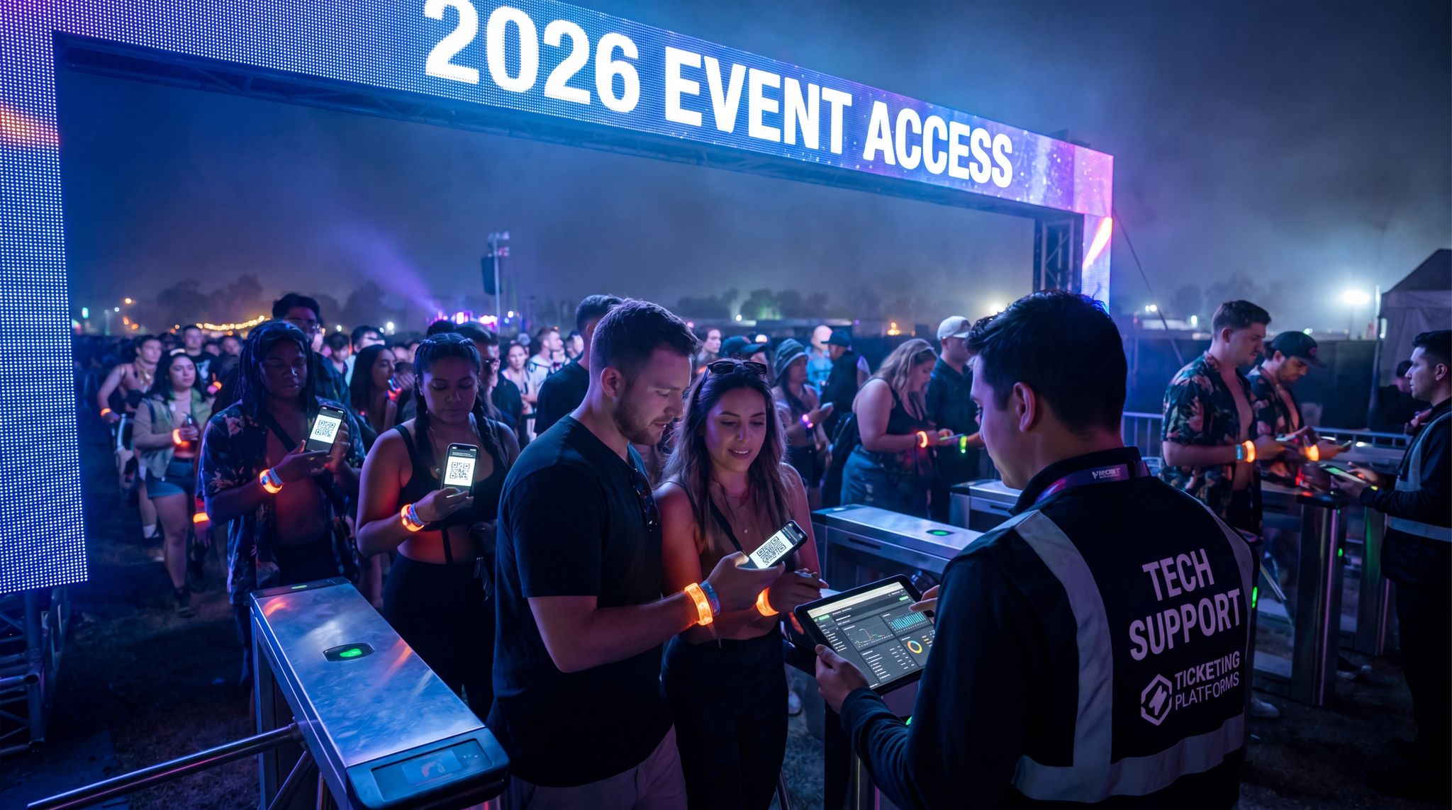
Smooth Entry With Mobile Check-In
Scan tickets and manage entry with our mobile check-in app. Supports photo ID verification, real-time capacity tracking, and multi-gate coordination.
When venue operators ask, “What is the best indoor navigation solution for events?”, the answer depends heavily on the facility’s infrastructure. The best indoor navigation solutions for events in 2025 and 2026 blend Ultra-wideband (UWB) precision with legacy Bluetooth Low Energy (BLE) beacons. This hybrid approach ensures that older smartphones can still receive general zone-level guidance, while newer devices unlock pinpoint, centimeter-level accuracy. For organizers managing sprawling, multi-level convention centers, investing in these dual-band systems provides the most reliable blue-dot experience currently available on the market.
Evaluating Top-Rated Digital Wayfinding Platforms
When upgrading venue infrastructure, organizers frequently ask how to select the best software for their needs. The top-rated digital wayfinding platforms in 2025 and 2026 integrate seamlessly with mobile apps – often the same ones that handle your event ticketing software – and utilize QR codes to bridge the gap between physical signage and personal devices. Leading cloud-based wayfinding solutions for venues now offer “app-less” routing. Instead of forcing attendees to download a heavy native application, these systems allow guests to simply scan a QR code displayed on a digital kiosk. The scan instantly launches a lightweight, browser-based interactive map—often featuring AR indoor navigation—right on their smartphone. For event producers, choosing a platform that supports this frictionless QR handoff is critical for maximizing user adoption and ensuring smart wayfinding investments actually reach the majority of the crowd.
Grow Your Events
Leverage referral marketing, social sharing incentives, and audience insights to sell more tickets.
When evaluating who offers cloud-based wayfinding solutions for venues, organizers should look toward specialized event tech vendors rather than generic digital signage providers. The most effective partners in 2026 provide end-to-end ecosystems—combining CMS dashboards, API integrations for ticketing, and hardware-agnostic deployment. This ensures that whether you are managing a temporary festival site or a permanent exhibition hall, the software can scale dynamically without requiring on-premise servers.
For operators managing massive, multi-use facilities, identifying the best indoor navigation platforms for large public venues in 2025 and 2026 requires looking beyond basic event apps. The top-tier systems now function as comprehensive spatial computing engines. These enterprise-grade solutions seamlessly integrate with existing building management systems (BMS) and Wi-Fi infrastructure to provide persistent, high-fidelity mapping across millions of square feet. Whether guiding a convention attendee to a breakout room or directing a stadium fan to their exact seat section, these advanced platforms ensure that complex, high-capacity environments remain easily navigable without requiring constant manual updates from the venue staff.
Dynamic Digital Signage and Kiosks
Real-Time Wayfinding Display Screens
Digital signage has become an indispensable navigation tool at conferences, trade shows, and festivals. Unlike static signs that are printed weeks in advance, digital wayfinding displays can update in real time. This flexibility is gold for events where schedules or layouts might shift. For instance, if a breakout session moves to a different room last-minute, your digital screens at the venue can instantly switch their arrows to point attendees the right way. Large LED signboards or LCD screens placed at junctions can cycle through directional information: “? Halls A–E | Halls F–J ?” might change to highlight one direction when a big keynote in Hall A is about to start. Many modern systems integrate with your event schedule data, so they know exactly when to display “Session X – this way” or when to show general info. Some screens even tie into sensor data – if an exit becomes congested, a screen might automatically promote an alternate route message. This eliminates the delay of humans noticing an issue and printing/moving a sign. At major festivals like Tomorrowland, giant LED boards near stages have been used to flash directional arrows to the nearest amenities (water, restrooms, exits) during breaks between performances. This dynamic approach provides info that static signs cannot offer. The ability to push out instant navigation updates keeps crowds flowing smoothly. When selecting digital signage for wayfinding, look for centrally managed systems (so one operator can change all signs at once), and ensure high visibility even in bright daylight if outdoors. Real-time updates are only effective if the screens are readable – meaning large text, bold colors, and placement where people naturally look when deciding where to go.
Beyond immediate directional arrows, operators are increasingly utilizing digital signage for trip schedules and transit integrations. By displaying live shuttle bus departures, ride-share wait times, or local train schedules directly on exit-facing screens, organizers can manage the egress flow much more effectively. This proactive communication prevents massive crowds from bottlenecking at the gates, as attendees can comfortably wait inside the venue until their specific transport is ready.
Data-Driven Event Marketing
Track ticket sales, demographics, marketing ROI, and social reach in real time. Exportable reports give you the insights to make smarter decisions.
High-Capacity Venues: Stadium and Arena Solutions
When evaluating the top digital signage solutions for stadiums and arenas in 2025 and 2026, operators must prioritize ruggedized hardware and ultra-low latency content management systems (CMS). Unlike temporary festival setups, permanent sports and entertainment complexes require enterprise-grade screens capable of withstanding extreme weather and continuous operation. The latest trends in digital wayfinding technology for these massive facilities emphasize deep integration with existing building management and ticketing systems. For example, a modern arena network can automatically switch from displaying pre-game concession promotions to emergency egress routing the moment a fire alarm triggers. By investing in these robust venue wayfinding platforms, stadium managers ensure that tens of thousands of fans can navigate concourses safely and efficiently, maximizing both concession revenue and overall guest satisfaction.
Interactive Touchscreen Kiosks
Another increasingly popular solution is the interactive wayfinding kiosk – basically a digital map that attendees can physically interact with on-site. These often appear as large touchscreens or tablets mounted around the venue (at lobbies, info desks, or key crossroads). A well-designed kiosk lets users do things like search for a stage or exhibitor by name, and then the map animates the route from the kiosk’s location to that destination. It’s the high-tech equivalent of the mall directory, tailored for your event. For example, a big trade show might place these kiosks at each entrance so visitors can find exhibitor booths instantly by tapping “Find Exhibitor” and searching alphabetically. Modern kiosks often include helpful features like QR code or NFC integration – after looking up directions, a user can scan a QR code to send the route to their phone, letting them carry on with step-by-step guidance. Some kiosk systems even support multiple languages: a simple flag icon on the screen can switch all text to Spanish, French, etc., making navigation inclusive for international attendees. The beauty of interactive kiosks is they provide personalized, self-service help without needing more staff. Attendees frustrated with a paper map can zoom, pan, and explore at their own pace. And beyond maps, kiosks can double as info hubs (showing event schedules, FAQs, or even a chat-bot assistant), providing a central point for all attendee needs, including information about your event ticketing system. Do note that kiosks can draw lines at peak times – a popular touch map might attract a queue. To mitigate this, festivals and theme parks often scatter multiple smaller touchscreens rather than one giant board, or deploy roving staff with tablets to act as “mobile kiosks.” Even on a budget, a couple of iPads in sturdy kiosks stands at strategic locations can significantly reduce wayfinding questions at your help desk. Just be sure to secure devices against theft or weather, and have a plan for power/internet (some use offline data with periodic sync, so even if Wi-Fi drops, the map still works).
Multilingual and Accessible Signage
Smart wayfinding is about helping everyone, not just the tech-savvy or English-speaking attendees. That’s why accessibility and inclusivity must be baked into your digital signage strategy. Fortunately, digital systems make this easier than static signs ever could. Multilingual support is a big one: a single digital sign can rotate through multiple languages (“Restrooms ?” can also display “Baños ?” or “Toilettes ?” for a few seconds each in areas with diverse crowds). Interactive kiosks can offer on-demand language switching or even provide audio directions in the user’s preferred language via a speaker or headphone jack. This ensures that international guests or those more comfortable in languages other than the host country’s can navigate confidently, enhancing accessibility and inclusivity at events. Various types of digital signage used in events can be adapted for these needs. Accessibility for those with disabilities is equally crucial. Wayfinding kiosks should be mounted at an appropriate height and angle for wheelchair users, and include options for audio output or screen reading for visually impaired users. Some kiosks include a physical button or sensor for an ADA mode that converts on-screen text to speech guiding the user. High-contrast display modes (e.g. white text on black background) help users with low vision or colour blindness. AR wayfinding apps can contribute too – for instance, an attendee with limited sight might benefit from their phone’s AR mode giving audio turn-by-turn directions or haptic feedback when they’re facing the right way. When evaluating digital signage software, consider compliance with standards like WCAG (Web Content Accessibility Guidelines) for kiosks and apps. Additionally, test your signage with diverse users: invite feedback from people with different languages and abilities during planning. An inclusive approach not only broadens your audience reach but also demonstrates care – something sponsors and stakeholders appreciate in today’s events. After all, seamless navigation should be for everyone in attendance.
Advertising and Sponsorship on Signage
Interactive wayfinding displays don’t just guide attendees – they can also serve as prime digital real estate for sponsors and important messaging. A balanced approach can inform your guests while giving partners valuable screen time. For example, an on-site digital sign might alternate between a map/directional mode and a “brought to you by [Sponsor]” message or a short promotional video when not actively in use. Because these screens draw eyes (attendees actively seek them out for info), sponsors love the visibility. Many 2026-era events monetize their digital signage to offset costs: think sponsor-branded map kiosks or rotating banner ads on the bottom of digital wayfinding screens. Just ensure the ads don’t overwhelm the useful info – navigation help should always remain the primary content. One clever tactic is embedding sponsorship into the wayfinding content. For instance, a festival’s AR navigation view might show a virtual arrow labeled “Main Stage – 5 min walk” with a subtle sponsor logo or a themed icon courtesy of a brand. Or the interactive map could have stylized “You Are Here – presented by XYZ” markers. These contextual ads feel more like part of the experience and less like interruptions. Beyond ads, use your screens for public service and engagement content when appropriate. They can display live social media feeds, fun facts, or safety reminders (“Stay hydrated – nearest water station 100m ?”). At the end of the day, every digital sign at your event is a communication channel. Filling downtime or screen space with valuable content – whether branded or informational – maximizes the ROI of your signage network. Just be sure to measure engagement (many digital signage systems provide analytics on which screens and content get the most interaction) so you can refine the balance of maps vs. messaging over time.
Cross-Industry Applications: From Festivals to Retail Spaces
The lines between temporary event grounds and permanent commercial venues are blurring. Today’s venue operators frequently manage mixed-use facilities, meaning the best wayfinding solutions for retail spaces in 2026 are often the exact same platforms powering mega-events. Whether you are directing attendees through a sprawling convention center or guiding shoppers through a pop-up festival merch village, digital signage wayfinding for events, conferences, and festivals translates perfectly to retail environments. By utilizing interactive kiosks and dynamic directional screens, organizers can seamlessly route foot traffic toward high-margin vendor zones. This cross-pollination of smart wayfinding technology ensures that investments made for a three-day expo can also serve the venue’s year-round retail concourses, maximizing overall hardware ROI.
Augmented Reality Navigation Tools
AR Wayfinding via Smartphones
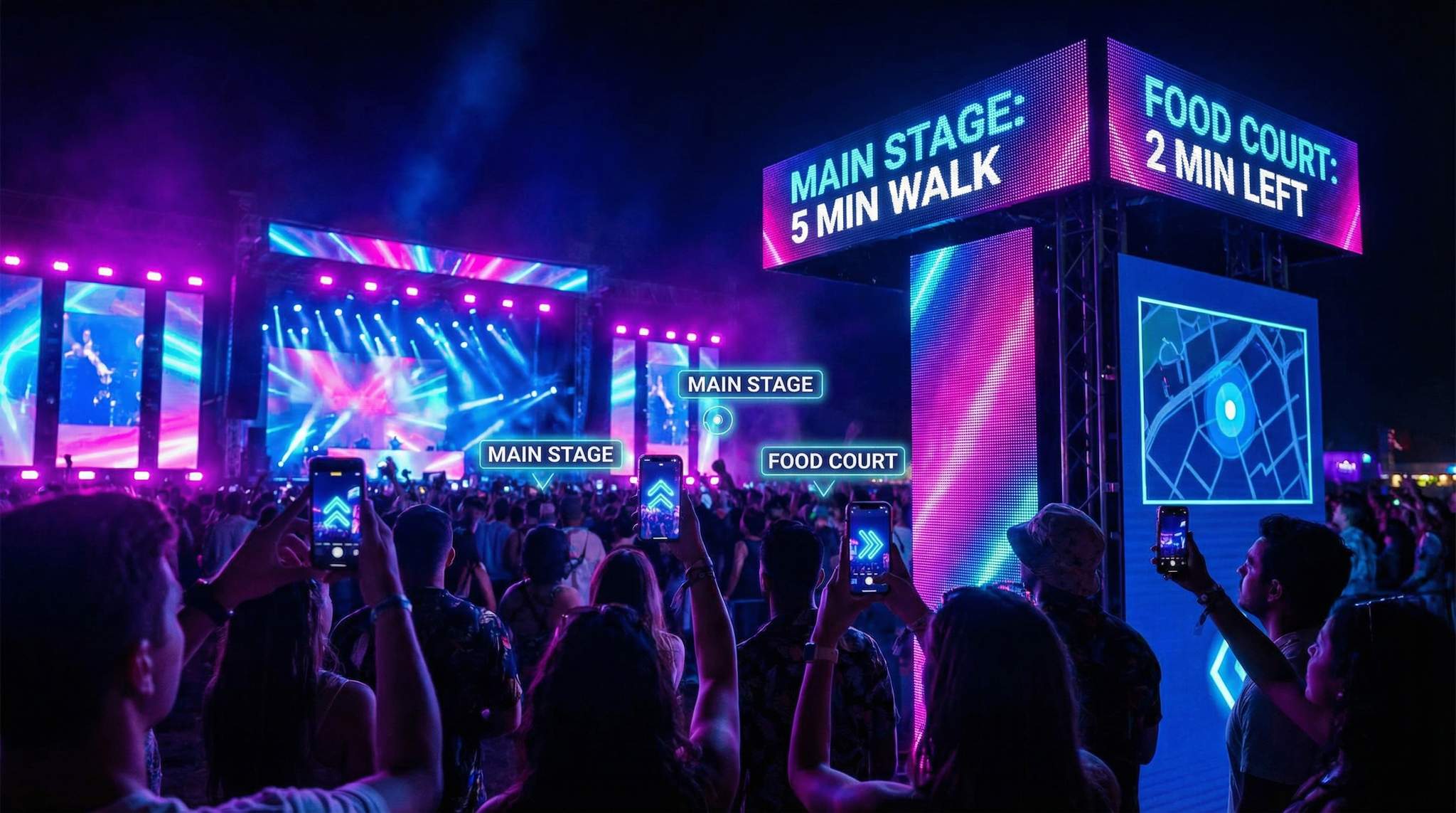
One of the most buzzworthy developments in event navigation is Augmented Reality wayfinding. This typically involves a user holding up their smartphone and seeing directional cues overlaid on the camera’s view of the venue. Instead of looking down at a 2D map, they see a virtual arrow on the ground in front of them pointing “this way to Stage 2,” or floating labels hovering over the actual tents or buildings they’re looking at (“Café, 50m ahead”). In 2026, AR navigation has moved from novelty to practical pilot at some big events. Major festivals have tested AR “compass” features in their apps that essentially give a 3D map of the grounds, creating augmented reality experiences at festivals. For example, a partnership between Snapchat and Live Nation rolled out an AR festival compass at multiple 2023 events, including EDC Las Vegas and Bonnaroo. Attendees could open Snapchat, point their phone around, and see tagged stage names and an AR route to get there – even find their friends’ locations if shared, as seen in Snapchat and Live Nation’s augmented reality concerts. Early results were promising: fans found it fun and intuitive, especially in sprawling sites where traditional maps felt overwhelming. The advantages of AR navigation are clear. It reduces the mental leap of translating a flat map to the real world – people just follow the arrows and labels superimposed on what they see, utilizing the camera view of the space to guide them intuitively to their destination. It can also reveal things that aren’t visible from where the person stands (e.g., “Restrooms behind this wall ?”). Many users report it feels faster and more natural, almost like a personal tour guide. And let’s not forget the wow factor – whipping out AR to find your next session adds a bit of high-tech magic to the event that can boost attendees’ perception of the overall experience.
The Power of AR for Engagement
Beyond pure navigation, AR wayfinding opens the door to playful engagement and rich information. Attendees can discover hidden content by exploring with their phone’s camera – perhaps unlocking a secret AR marker that displays a fun fact or Easter egg about a stage they’re approaching. Organizers are also using AR to add context on the fly. For instance, pointing your phone at a stage could not only show its name but also list the current performer and next up in the schedule, allowing fans to follow virtual arrows or markers. Furthermore, AR can highlight real-time details they might have otherwise missed. This is incredibly useful at multi-stage festivals or large conventions – you might stumble upon a stage and instantly know what’s happening there now and later, without digging through schedules. AR wayfinding can be sponsored too: e.g., a tech conference had an AR overlay where certain booths on the expo floor glowed with a sponsor’s color and logo when viewed in AR, effectively guiding interested attendees to those partner exhibitors. Some events have turned AR navigation into a game (a scavenger hunt where you follow AR clues around the venue), creating a unique exploration challenge that also ensures people learn the layout. The key takeaway is that AR can make navigation interactive and fun, not just utilitarian. It invites attendees to actively engage with their surroundings through their screens, blending information with a sense of discovery.
Implementing AR Navigation: Tips and Challenges
For those considering adding AR wayfinding to an event, there are important technical and design factors to get right. Firstly, precise indoor mapping and positioning is a must – AR directions are only helpful if the digital overlay lines up correctly with real-world locations, ensuring augmented pathways transform conference wayfinding effectively. It is vital that landmarks and markers are precise. This means investing time to create accurate 3D maps of your venue or geo-anchor points. AR navigation often uses either SLAM (Simultaneous Localization and Mapping) algorithms via the phone camera or location tech like the aforementioned beacons/UWB to figure out where the user is looking. Either way, plan a thorough venue scan or beacon installation and calibrate it well before the event. Secondly, keep AR content simple and clear. It can be tempting to clutter the view with lots of floating icons, but users can get overwhelmed. Instead, use clear arrows, a few key labels (like major stage names or “Exit this way”), and perhaps distance indicators. High-contrast graphics that stand out against a variety of backgrounds (crowds, tents, foliage, etc.) are important, since AR overlays merge with reality. Performance is another factor – AR can be heavy on device CPU and battery. Optimize the app so it doesn’t lag or drain phones too quickly. Many events use lightweight WebAR approaches (where people just click a link, no heavy app install) for scavenger hunts, but for continuous nav you’ll likely integrate into your main app. Always provide a fallback: not everyone will use or be able to use AR mode, so standard maps and signs must coexist (never assume 100% AR usage), ensuring the system remains responsive even in busy areas or where device compatibility is limited. Finally, test the AR navigation in real-world conditions – what looks good in an empty venue might falter when thousands of people fill the pathways or if lighting conditions change at night. Run small pilots or beta tests during setup, and have staff try to follow AR directions to ensure they’re intuitive. With good planning, AR wayfinding can be a futuristic addition that genuinely helps attendees. Just approach it as an enhancement of your overall wayfinding system, not a total replacement.
AR Glasses and Future Directions
Looking ahead, we may soon see attendees navigating via AR glasses or headsets at events. While still niche in 2026, lightweight AR eyewear is improving, and a few pioneering events have experimented with providing AR glasses to VIP guests or using them in guided tours. For example, a tech expo ran a trial where attendees wearing AR glasses saw floating directional cues and exhibitor info as they walked, hands-free. This kind of immersive guidance could eventually eliminate the need to hold up a phone. However, current barriers include cost, the need for attendees to be comfortable wearing devices, and technical hurdles in mapping content to a moving viewpoint smoothly. In the meantime, public AR displays might bridge the gap. Think of a digital sign that uses AR-like overlay: e.g., a large screen showing a camera view of the lobby with an arrow overlayed pointing to “Registration this way”. It’s like a window with AR guidance that anyone can look at. Some high-end venues are exploring this for complex junctions – the screen basically acts as an AR navigator for the crowd. We might also see augmented audio for wayfinding: apps that provide directional audio cues (“pinging” louder in your left ear to nudge you leftwards, for instance). Ultimately, the evolution of AR in event navigation will track with consumer tech. As AR becomes more common in everyday navigation (in-car AR displays, AR walking directions in city map apps), events will integrate it more deeply. The goal will always be the same: reduce friction and make finding your way feel effortless, whether via a phone, glasses, or some yet-to-be-invented gadget.
Digital Wayfinding Trends 2026: The Convergence of AR and Indoor Mapping
As we look at broader digital wayfinding trends for 2026, the most significant shift is the seamless integration of spatial computing into standard event apps. The leading digital signage wayfinding trends point toward a hybrid approach where physical LED screens hand off directions directly to a user’s smartphone camera. Specifically, AR indoor navigation is becoming highly requested for complex, multi-level convention centers where traditional GPS fails. Venue architects and event producers are now collaborating to pre-map facilities with spatial anchors, ensuring that when an attendee scans a digital sign, their phone instantly generates a persistent, augmented 3D pathway to their next session or meeting room.
Tracking digital signage wayfinding trends, AR indoor navigation in 2026 is moving away from standalone novelty apps and integrating directly into core event management platforms. One of the most prominent digital wayfinding trends for 2026 is the use of WebAR triggered by QR codes on physical signs. This means an attendee can walk up to a digital signage wayfinding display at events, conferences, or festivals, scan a code, and instantly see augmented directional arrows on their screen without downloading a heavy application. This frictionless handoff between stationary hardware and personal devices represents the pinnacle of smart wayfinding technology.
Furthermore, keeping pace with the latest trends in digital wayfinding technology for 2025 and 2026 means recognizing that event wayfinding is no longer just about static maps. Organizers are increasingly demanding platforms that offer predictive analytics. By analyzing historical foot traffic data, these advanced systems can preemptively adjust digital signage to prevent bottlenecks before they form, ensuring a frictionless journey from the entrance gates to the final keynote or encore.
Go Cashless With RFID Technology
Enable contactless payments, faster entry, and real-time spending analytics with RFID wristbands and NFC-enabled ticketing for your events.
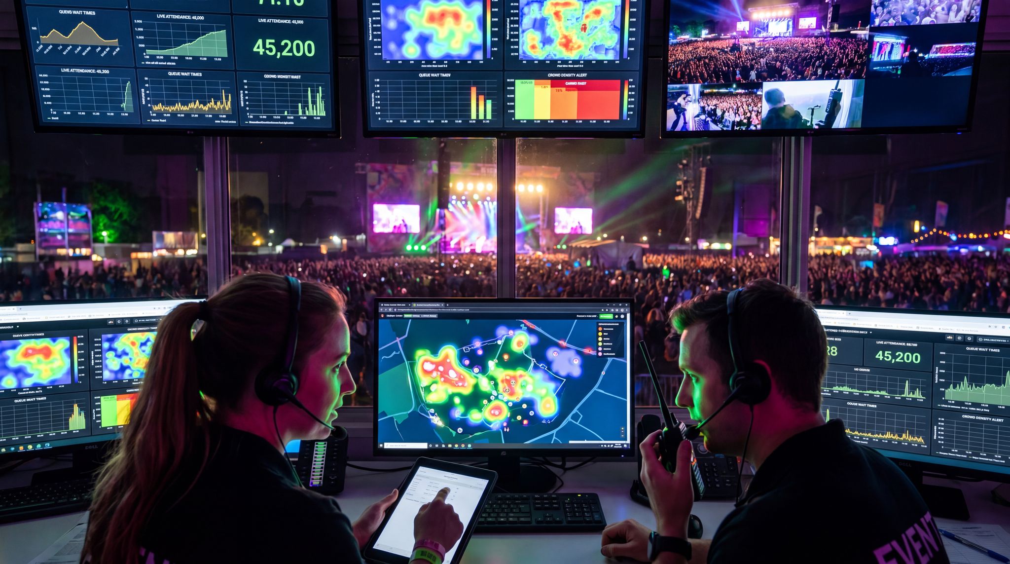
IoT-Enabled Routing and Live Crowd Management
Crowd Sensors Powering Dynamic Directions
One of the most powerful developments in seamless attendee navigation is the integration of IoT sensors and real-time crowd data. By instrumenting a venue with people counters, smart cameras, and other sensors, event organizers can react instantly to congestion or imbalances – often before attendees even realize there’s an issue. Here’s how it works: networks of sensors (like overhead 3D cameras that anonymously count heads, or infrared beams at chokepoints) feed a live dashboard of crowd density, keeping track of how many people are in specific zones. If one area starts filling up beyond comfort, the system flags it. Now tie that into wayfinding: digital signs can automatically redirect foot traffic based on sensor inputs. Knowing where people are allows for on-the-fly directions to smooth out crowds. For example, if the west exit from a stadium is getting packed post-concert, digital signage and the event app might start suggesting the east exit to some attendees (“? For a faster route to Parking Lot B, turn right”). Similarly, if one set of restrooms shows a long queue (some venues use sensors on doors or AI camera counts for this), nearby screens might display “Restrooms ahead busy – try ones left of stage”. This kind of dynamic routing was a futuristic concept a decade ago; now it’s increasingly real. The Johan Cruijff ArenA in Amsterdam is a notable case – it employs an AI camera system to monitor crowd flow and line lengths in real time, triggering announcements and messages that gently steer people to less crowded entry gates and concessions. For instance, AI can detect if one corridor consistently jams and suggest alternatives. This often involves app integration where sensors detect congestion, influencing behavior in real time. By smoothing out the crowd distribution, they’ve cut down bottlenecks and shortened wait times significantly. The key to success is subtlety and trust: attendees don’t want to feel bossed around by robotic instructions. But if they see a screen or receive a push alert saying “? Busy ahead, faster route this way ?”, most appreciate the guidance. Over time, people learn to trust that the event’s navigation system truly has the latest info. It’s like Waze for pedestrians at an event – rerouting you around jams in real time. Implementing this requires linking your sensor network with your communications channels (apps, signs, even audio PAs). Many advanced venues are now essentially smart buildings that do exactly this, as part of holistic IoT-driven venue operations. Even if you start small – say, just monitoring one or two key areas and manually updating a sign when needed – you’re on the path to smarter crowd flow management.
Shorter Lines Through Smart Queuing
Nobody likes waiting in line, and smart wayfinding tech is helping attendees avoid unnecessary queuing by making queue information transparent. This goes hand-in-hand with crowd sensors as mentioned above. Imagine arriving at a food court with three vendor stands – one has a 3-minute line, the others 10+ minutes. If attendees can see that information, many will naturally redistribute. Events are beginning to show estimated wait times on digital signage (“Current wait at Beer Garden: ~8 minutes”) or in the mobile app. Some have experimented with color-coded indicators on maps or signs: e.g., bathroom icons that glow green (short wait), yellow, or red (long wait) based on real-time data. Disneyland-style, you can even push notifications: “? Water station by Gate 1 has no line right now.” The data source can be anything from manual staff inputs via an app to fully automated counts (e.g., an AI camera estimating the queue length). The effect is subtle social engineering – when people see one line is clearly shorter, they’ll head there, balancing the load. This not only reduces individual waiting times but also prevents any single queue from getting out of hand. From the organizer’s perspective, it means better service distribution and happier attendees who feel in control of their time. One word of caution: make sure the info you display is accurate! Publishing wait times that are way off will erode trust quickly. Start with a few key services (maybe just entry gates and one food area) and refine the process. Monitor how attendees respond – do they actually redistribute when informed? Often the answer is yes. Over multiple days, you can fine-tune thresholds for what triggers a public alert (you might not bother people for a 3 vs 5 minute difference, but definitely alert if one queue is 3x longer than another). By leveraging these techniques, some festivals have cut peak wait times by 20-40% anecdotally, simply by “load balancing” the crowds in real time. In essence, you’re using tech to do what a good operations manager would do with megaphones and staff redirects, but far more efficiently and calmly.
Emergency Wayfinding and Alerts
Perhaps the most critical application of smart signage and wayfinding tech is in emergency situations. When something goes wrong – a severe weather alert, a fire alarm, a security incident – getting people to safety quickly and orderly is paramount. Digital signage and automated alerts can save precious minutes and prevent panic by providing clear instructions exactly where needed. In a modern smart venue, the moment an emergency is detected, the system can override normal content on all displays with emergency messaging. The benefits of smart crowd management include automated voice announcements, and because the system knows exactly how many people are present, it can react before human operators might. For example, if a fire alarm triggers in Zone B of a convention center, screens in that zone and adjacent areas will instantly flash evacuation arrows: “EXIT ? “, guiding folks to the nearest safe exit (which the system knows, based on where the alarm is). Simultaneously, an audio announcement might play in multiple languages with instructions. Because this can all happen within seconds of an alarm (and targeted to just the affected areas), people receive guidance faster than waiting for human decision-makers to react. Real-world case studies show this in action: many outdoor festivals now link weather data to their crowd notification systems. If lightning is detected within a certain radius, screens around stages automatically display “?? Lightning in area – seek shelter immediately” and point to exit routes or sheltered areas, while stage managers pause performances. A concrete example comes from systems using a programmed script that is triggered by weather alerts. This automated alert can initiate even before the organizers have hopped on radios, buying time for thousands to start moving to safety. Another example: at large sports arenas, if crowd analytics detect a sudden surge or stampede-like movement, it can trigger all exit door signs to turn green and pulse, subconsciously encouraging people to move out through those doors. In parallel, alerts go to security staff’s devices so they can respond. All of this paints a picture of an integrated emergency response where wayfinding tech plays a frontline role – lighting and guiding the path to safety. Importantly, you must test these systems (nobody wants an accidental false alarm on show day). But when done right, smart wayfinding ensures that even in chaos, attendees see authoritative, calming direction on where to go. This not only improves actual safety outcomes but also perceived safety. Knowing that “if something happens, the screens will tell me exactly what to do” gives attendees peace of mind. As you plan your wayfinding deployment, involve your safety team to integrate these capabilities. It’s one tech investment you earnestly hope you’ll never fully need, but if you do, it could be a lifesaver.
Integrating Weather and Traffic Data
Attendee navigation isn’t only about moving within the venue – it starts from the journey to get there. Smart wayfinding now extends to integrating external data like traffic, transit, and weather to provide a truly seamless journey. Many event apps in 2026 pull live traffic maps or transit updates on the event day, so attendees see not just the venue layout but also suggestions for the best entrance to use based on where congestion is. For example, a stadium app might pop up a message as you approach: “Heavy traffic on the north approach – use Gate D for faster entry.” This is powered by connecting to services like Google or Waze, or city transit APIs for real-time info. On the weather front, beyond emergency severe weather alerts, general forecasts can be tied into signage messaging. If the day turns out hotter than expected, digital signs can remind “Stay hydrated – free water at blue tents” or even redirect people to shaded rest areas. Rain on the radar? Screens might suggest indoor exhibit areas during the downpour. Some outdoor event organizers have gone as far as using small IoT weather stations on-site feeding into their systems, so microclimate info (like a sudden high wind in one part of a large festival grounds) can trigger targeted alerts or adjustments. An example is a race track that uses on-site wind sensors – when wind kicks up beyond a threshold, signs around stages notify attendees to secure loose items (preventing debris blowing) and operations might pause certain high structures to ensure AI-powered venue operations enhance efficiency. This level of integration builds retail insight and consumer safety directly into the infrastructure. All these measures essentially treat navigation as end-to-end: from leaving home to returning home. It’s a holistic view. When you design wayfinding for your event, think about partnering with local transit (many cities will allow event-specific messages on public transit signs or apps), and make use of data integrations offered by your event tech providers. The goal is to proactively guide attendees throughout their journey, adapting to conditions. Not only does this reduce frustration (“the parking directions on the app saved me 30 minutes!”), it can also increase attendance and on-time arrival. People are less likely to skip an event due to logistical hassles if they know the organizers have their back in navigating those hassles.
Right-Sizing Wayfinding Tech for Any Event
Small Events: Affordable Navigation Hacks
Not every event has the budget of Coachella or a high-tech convention center – and that’s okay. Smaller events (say, a 500-person conference or a community festival) can still greatly improve attendee navigation with clever, low-cost solutions. The first principle is to keep it simple: in an intimate venue, you may not need AR or a sensor network at all, just well-placed signs and perhaps a basic digital component. One affordable tactic is using consumer tablets or screens as mini digital signposts. For a conference in a hotel, you might place a few iPads on stands at key hallway intersections running a continuous slideshow with arrows (“? Session Rooms | Keynote Hall ?”). Free or cheap software can power these DIY kiosks, or even a looping PowerPoint can do the trick. Another hack: utilize QR codes on printed signs. Print a poster with a static map and a prominent QR code that says “Scan for Interactive Map on Your Phone.” The QR could load a simple mobile-friendly webpage map or even a Google Maps indoor custom map if you’ve created one. This way, without a custom app, guests can at least pan and zoom a digital map on their own device. For outdoor community events, consider borrowing tech – maybe the local university has rentable digital sign boards, or your AV vendor can repurpose an LCD TV cart to show maps. The key is to identify the biggest pain points at your event (Is it finding parking? Locating the single stage? Navigating a few breakout rooms?) and focus tech efforts there. Often, just a clear digital schedule screen at the entrance and a couple of large printed maps will do wonders. Also, leverage what attendees already have: their phones and readily available apps. Encourage use of basic tools like Google Maps if applicable (“Venue name is pinned on Google Maps, navigate to the main gate here”). For indoor small venues, an app might be overkill, but a PDF map or interactive web map linked in emails can suffice. Small events can also tap into affordable event tech solutions – for example, there are budget-friendly signage software plans and even open-source wayfinding apps that cost a fraction of enterprise systems. The bottom line: you don’t need a $100k system to make navigation easier. With a bit of creativity, even a low-budget approach can yield a high impact on attendee ease and satisfaction.
Deploying with Minimal Hardware and Managing Costs
A common concern for independent promoters is the smart wayfinding solution installation cost. Fortunately, you don’t need to wire a massive network of permanent screens to see results. If you want to deploy a wayfinding system with minimal hardware in 2026, the secret lies in leveraging the devices attendees already carry. Cloud-based wayfinding digital signage platforms allow you to cast dynamic maps to a handful of rented smart TVs or even standard tablets mounted on floor stands. By pairing just two or three strategic digital displays with a robust mobile web map accessed via QR codes, organizers can drastically reduce upfront infrastructure expenses. This lean approach to digital wayfinding delivers enterprise-level guidance without the enterprise-level price tag.
Free Tool: When Should You Announce?
Pick your event date and genre — the free planner outputs a recommended announce, presale, on-sale and reminder schedule anchored to how your audience actually buys.
Mid-Sized Events: Balancing Tech and Practicality
For mid-sized events like a 5,000-person festival or multi-track convention, navigation challenges increase, but you still may not have a massive war chest for fancy tech. The strategy here is to prioritize the most effective tools that give you the best bang for your buck. First, invest in a user-friendly mobile map – either via your ticketing platform’s app or a third-party event app provider – since attendees at this scale will appreciate a digital map. Ensure it works offline (downloadable map data) because with a few thousand users, cell networks can get spotty. Next, consider a handful of digital signage points in lieu of dozens. Maybe rent four large LED screens: one near entry, others at big decision points (forks in foot traffic). Use these for rotating directions and schedule highlights. Keep static signage as a backbone (banners, flags, printed maps), while digital signs handle updates and attention-grabbing alerts. Mid-size venues can benefit from zoning and landmarks too – a trick from mega-festivals that can simplify wayfinding without any tech at all. For example, break the site into Zones A, B, C and put that on signs and in the app map (“Food Court – Zone B”). Even a 5k festival can feel daunting to newcomers; a simple code or color system makes it friendlier. If budget allows, a couple of touchscreen kiosks or info booths are great for mid events. They serve as a bridge for those who didn’t download the app. Another mid-range tech option is using SMS or messaging apps for navigation support. For instance, attendees can text a code like “FIND STAGE 2” to a number and get back directions or a link to a map pin – services like this can sometimes be cheaper than full native app development. You also might harness volunteer staff with tablets as roaming helpers who can look up info quickly. Mid-sized event organizers often wear multiple hats, so look for tech that integrates easily (avoid standalone systems that need a dedicated operator if you’re tight on staff). Many trade shows and expos embrace smart navigation tools for mid-sized crowds that double as engagement boosters – e.g., an interactive floor plan that also highlights sponsored booths. Steal those ideas to both serve attendees and keep exhibitors/sponsors happy. In short, mix digital and analog thoughtfully: enough tech to handle complexity, but not so much that it overwhelms your team or your attendees.
Mega-Events and Large Venues: Full-Stack Navigation
When you’re dealing with a massive event – a 50,000+ music festival, a stadium concert, or a multi-hall trade expo – that’s when the full arsenal of wayfinding tech truly comes into play. Large-scale events should approach navigation as a system-of-systems, where mobile apps, signage, AR, staff, and sensors all interconnect. Here, robust infrastructure is key: you’ll need reliable site-wide Wi-Fi or cellular coverage (or offline-capable tech) to support thousands using the app map simultaneously. Big venues often deploy a command center specifically to monitor crowd movement and adjust wayfinding in real time, proving the point that at scale, navigation is an active operation. For example, the team might watch CCTV or heatmaps and decide to temporarily change digital sign messaging to spread people out – essentially manual dynamic routing. But increasingly, large venues lean on automation as discussed earlier: the integration of IoT crowd monitoring with automated signage and alerts is becoming the gold standard. If you have multiple halls or stages, strongly consider AR wayfinding features in your app to wow the crowds and assist in those particularly confusing moments (it’s much easier to follow an AR arrow in a huge field than to interpret a grid coordinate on a paper map). Large events can also justify more hardware: dozens of digital screens, a fleet of touch kiosks, even renting large LED trailers that display maps at campgrounds or parking lots. A festival city of 100,000 people might set up info towers with 360° LED banners that scroll navigation tips all day and night. Don’t underestimate the importance of old-school methods at this scale too – huge physical landmarks (giant balloons, colour-coded zone flags viewable from afar) greatly aid orientation, and the tech can complement that by showing “You are in the Red Zone” on an app or screen. When festival wayfinding becomes a story, the path becomes an adventure. Using playful, thematic icons ensures everyone feels included. Another must for mega-events: dedicated wayfinding staff teams. You might have a crew solely focused on monitoring and responding to navigation issues (e.g., dispatching volunteers to redirect foot traffic if a path gets closed). Tools like digital twins can be brilliant in the planning phase for large venues – you can simulate crowd flows and test different signage placements virtually. You can run a simulation on the venue layout to predict flow. For instance, testing a match at a specific concession area allows you to simulate the impact of different setups, refining your plan long before gates open. Ultimately, big events demand big coordination. But with a full-stack approach – think festival control room tracking live data, feeding updates to apps, signs, and announcements in unison – it’s possible to shepherd enormous crowds with a level of precision unimaginable in the past. The payoff is huge: smoother flow, fewer safety incidents, and far happier attendees who can focus on the event, not the logistics of finding their way around.
Ultimately, the foundation of this full-stack approach relies on scalable wayfinding technology for large venues. As an event grows from a regional fair to a sprawling multi-day festival, the underlying infrastructure must expand without requiring a complete rebuild. Modern cloud-based wayfinding solutions for venues allow operators to seamlessly add new digital endpoints—whether that means integrating fifty additional LED screens or expanding the mobile app’s map grid—from a single centralized dashboard. This modular approach to venue wayfinding ensures that your initial technology investment remains viable, adapting effortlessly as your footprint and attendee capacity increase year over year.
Implementation Best Practices and Tips
Plan Early and Map Everything
Seamless navigation doesn’t happen by accident – it starts in the event planning phase. One of the best practices is to create detailed site maps and wayfinding plans as early as possible. As soon as your venue layout is known, map out all attendee pathways: entrances, exits, main routes, potential choke points, locations of key amenities. From this, you can decide where physical signs are needed and where digital aids would be most effective. Many seasoned planners now incorporate digital twin simulations to eliminate surprises. Planners can run a simulation on the venue to foresee issues. By building a virtual model of your event site and simulating crowd flow, you can identify confusing intersections or areas likely to congest. For example, a simulation might reveal that two popular attractions are adjacent, creating a pinch point at certain times – so you could plan additional directional signs or a one-way foot traffic system there. Treat navigation as a storyline: “Attendee arrives at parking, follows signs to gate, scans ticket, then what? Where do they naturally go next?” Answer those questions in your plan. It helps to create a wayfinding journey map for different attendee types (a VIP’s journey might differ from GA, an exhibitor’s path differs from public). Once you have a plan, coordinate it across all teams – ops, production, marketing, and vendors. The folks printing banners need the same zone names/colours as the app developers building the map. Consistency is king. Use collaborative tools – even a Google Map with pins or an event CAD diagram – to make sure every stakeholder knows the navigation layout. By locking in the wayfinding strategy early, you also have time to procure or develop the needed tech: ordering signs, configuring software, mapping the venue in an app. Last-minute changes to layout are inevitable, but if you’ve mapped out Plan A and Plan B thoroughly, your tech can adapt with minimal fuss. Think of it this way: you’re not just designing a venue, you’re designing an experience of movement. A well-planned navigation system often goes unnoticed by attendees (because it works), while a bad one is painfully obvious. So give wayfinding planning the time and attention it deserves upfront.
Testing with Fresh Eyes
Usability testing isn’t just for apps – test your entire wayfinding system in real-world conditions. Before opening day, invite people who are completely unfamiliar with the venue (friends, junior staff, even a few random volunteers) to perform a navigation exercise. For example, bring in a handful of test attendees during rehearsals or setup and ask them: “Here’s your task – you’ve just entered, now find the VIP lounge, then the main stage, then an exit.” Observe without coaching. See where they stumble: Did they miss a sign? Was a label confusing? Did the app map orientation throw them off? These fresh eyes will catch issues you, as an insider, might overlook. You should test your wayfinding system with fresh eyes and then step back and watch. Ask them if they got lost at any point and why. As noted earlier, a common test finding is inconsistent naming – e.g., a tester might not realize “Blue Zone” on a sign is the same as “Zone C” on the map (cue to unify those names). If testers got lost at any point, use that feedback to make quick fixes: add an extra sign, change an icon, adjust the app legend, etc. Testing should also cover digital elements: have someone try using the app alone to find locations – do they get lost in the interface? Does GPS or positioning actually work on-site? If you have AR, definitely test it in the exact environment (crowd density, lighting can greatly affect AR performance). Don’t forget to test accessibility: maybe ask someone with color-blindness or someone in a wheelchair to assess if signage is visible and routes are clear for them. Additionally, run through some edge cases: How does wayfinding hold up at night? Are all signs lit? What about when there’s a huge crowd at the end – can people still see the exit signs, or are they obscured by the throng (in which case elevated signs or repetitive overhead signs might be needed)? Logistics drills can help too – e.g., have security or volunteers do a timed run from the furthest point of the site to the first aid tent, purely by following signs, to ensure emergency access is clear. The goal of all this testing is to uncover and fix flaws before your real attendees do. As the saying goes, “No battle plan survives contact with the enemy” – similarly, no wayfinding plan survives first contact with attendees unscathed. But by testing and iterating, you can catch 90% of the snags. The result will be a polished system where on event day, navigation feels intuitive and hassle-free.
Training Staff and Volunteers
Even in the age of apps and automation, human assistance remains a cornerstone of seamless attendee navigation. Your staff and volunteers are walking, talking signposts and should be equipped to complement the high-tech tools. Make sure all front-line personnel (ushers, info desk staff, security, roaming volunteers) are intimately familiar with the venue layout and have seen the maps. A brief training session or site walk can work wonders – take your team on a tour of the grounds during setup, pointing out zone names, entry/exit routes, and any tricky spots where people might need extra help. Provide them with cheat sheets: maybe a small printed map in their pocket or accessible on their devices. Critically, ensure staff know how to use the navigation tech themselves. If there’s an event app, all staff and volunteers should have it installed and be comfortable pulling up the map or schedule on it. That way if an attendee asks for directions, a staffer can quickly show them on the app (“Look, here we are, and you need to go here”). Some events give radios or chat app access to a central info team so staff can quickly ask “Is Route A or B clear right now?” and get an answer if needed. Also train staff on contingency plans: if tech fails (say, the app server goes down or a digital sign blacks out), what’s the protocol? Perhaps volunteers are instructed to manually steward people if an outage occurs. Make sure staff know the intended flow of people – e.g., “Attendees should exit to 7th Street, not back through the entrance” – so they can gently redirect anyone going the wrong way. In high-traffic periods, position staff at key decision points to actively guide – their waving arms or verbal cues can reinforce what signs are saying. A friendly human touch also eases stress in navigation, especially for those less inclined to use gadgets. Lastly, encourage your crew to give feedback during the event. They’re the ears on the ground; if multiple guests keep asking “Where is X?”, that might indicate a signage gap which you can still address in real time by deploying a temporary sign or notification. In essence, treat your team as part of the wayfinding system – well-informed humans are as crucial as the smartest app in ensuring everyone finds their way with minimal fuss.
Interactive Seating for Every Venue
Let fans pick their perfect seat with interactive venue maps. Supports reserved seating, section-based pricing, and real-time availability.
Backup Plans for Connectivity and Power
Redundancy is the name of the game when it comes to event tech, and wayfinding is no exception. You must plan for offline and low-tech backups in case your shiny digital systems hit a snag. First and foremost, always have printed maps and signs as a safety net. Even at the most high-tech events where every attendee is glued to an app, you’ll see paper maps handed out or large static maps posted on walls. They are not redundant – they are your fail-safe if the Wi-Fi dies or phones run out of battery. Printed maps should be accurate and as up-to-date as possible with any last-minute layout changes. If you can’t reprint something changed, at least brief info booth staff on the discrepancy so they can verbally correct it. Next, design your digital solutions with offline capability. This means making sure your mobile map works without constant data – ideally users download all map data and schedules on first launch (or when connected) so later it works in a network dead zone. Many events explicitly remind users: “Open the app at home to cache the map for offline use.” For web-based maps or info, consider providing an offline PDF as a backup download. For signage, power backup is crucial: put important digital signs on UPS (uninterruptible power supplies) or have generator hooks if the mains fail. Also, keep a few whiteboards or chalkboard signs in storage. If something unexpected occurs (like you need to close a path due to a hazard), an old-fashioned handwritten sign “Path Closed – use west gate” placed strategically can do the job in a pinch. Some events station runners on radios who can deploy these temporary signs or barriers on short notice. In worst-case scenarios, you might need to revert to human megaphone navigation: security or volunteers literally shouting directions if tech collapses (hopefully it never comes to that, but at least discuss it in your risk planning). We’ve all heard real disaster stories of tech failing at critical moments. Discover how cutting-edge infrastructure helps venues run smarter, but backups are still essential. The events that recover best are those that prepared backup workflows. One pro tip is to print a small batch of “In case of tech outage” info leaflets – maybe a single page with a map and schedule – that can be handed out if your app or digital system goes offline. It shows attendees you’re on top of it, rather than leaving them in the dark. Ultimately, by building resilience into your wayfinding approach, you ensure that no single point of failure will leave your crowd directionless. The show must go on – and the crowd must go out (to where they need to be) – regardless of any surprises.
Measuring Success and ROI
After the event, it’s important to evaluate how your wayfinding solutions performed. This is both to justify the investment (to your bosses or clients) and to learn how to improve next time. Start with any data you have: many digital platforms can show analytics such as app map usage (e.g., number of map views, popular search terms), or kiosk interactions (e.g., which destinations were most queried). If you used sensors, you’ll have crowd flow data that can be analyzed for patterns: did people actually distribute among exits as expected? How long were queues on average? Pair this quantitative data with qualitative feedback. Look at your post-event surveys for any mentions of navigation or signage. If you don’t have a specific question on it, consider adding one: “How would you rate finding your way at the event?” or “Any areas you had trouble locating?”. Often attendees will volunteer this info if something was frustrating (“I kept getting lost between Stage 2 and the camping area”). Also debrief your front-line staff: they know where the pain points were by the questions they got. Maybe the info booth logs show 50 people asked where the shuttle pickup was – a sign that needs better signage or pre-event communication about that. On the flip side, celebrate the wins. If you introduced, say, an interactive map this year, did it reduce the load on staff for directions compared to last year? One conference saw a 40% drop in “help me find…” questions after adding digital wayfinding kiosks, as wayfinding digital signage guides suggest, which they used as evidence of success. Sometimes ROI can be measured in harder terms too: faster navigation can lead to more concession sales (less time wandering, more time buying food), or improved crowd flow can allow you to safely host more people (capacity). If you have any such metrics – like revenue per attendee up because people aren’t stuck in lines, or entry throughput improved (e.g., “we got everyone inside 15 minutes faster than previous events”) – highlight that. These outcomes build the business case for continuing to invest in wayfinding tech. In formalizing this, some tech-forward organizers do a post-event tech audit where each system (including navigation tools) is reviewed for performance and ROI. This analysis can reveal how to achieve shorter lines and faster service or create comfortable environments and personalization. This is a great practice: you might discover, for example, that one fancy feature was rarely used and can be cut to save cost, while another simple feature was a huge hit and merits more focus. Continuously learning from each event means your navigation strategy will only get stronger with time, just like any other aspect of event production.
Frequently Asked Questions About Event Wayfinding
What are the best indoor navigation solutions for events in 2025 and 2026?
The top solutions combine Ultra-wideband (UWB) technology, BLE beacons, and Wi-Fi triangulation to provide accurate, real-time “blue dot” routing on attendee smartphones. The ideal choice depends on the venue’s existing infrastructure and the required level of precision.
How can organizers reduce smart wayfinding solution installation costs?
To minimize smart wayfinding solution installation costs, organizers can utilize cloud-based wayfinding digital signage software paired with rented commercial displays or tablets. Leveraging attendees’ own mobile devices via QR-triggered WebAR maps also drastically cuts down on the need for expensive, permanent hardware.
How does digital signage wayfinding benefit retail spaces compared to events?
The best wayfinding solutions for retail spaces in 2025 and 2026 utilize the exact same dynamic routing and interactive kiosk technologies proven at mega-events. In both environments, these systems seamlessly guide foot traffic toward high-value zones, whether that is a festival merchandise tent or a permanent shopping concourse.
What makes scalable wayfinding technology essential for large venues?
Scalable wayfinding technology for large venues allows operators to expand their navigation systems—such as adding more digital screens, interactive kiosks, or app-based map zones—without overhauling the core software. Utilizing cloud-based wayfinding solutions ensures that as an event’s footprint grows, the venue wayfinding infrastructure can seamlessly adapt to handle increased crowd density and complexity.
What features define the top-rated digital wayfinding platforms in 2026?
The top-rated digital wayfinding platforms in 2025 and 2026 integrate directly with mobile apps and utilize QR codes for frictionless access. Leading cloud-based systems allow attendees to scan a code on a physical sign to instantly launch browser-based AR indoor navigation, eliminating the need for mandatory app downloads while providing seamless, turn-by-turn guidance.
What are the best indoor navigation platforms for large public venues in 2025 and 2026?
The leading platforms for massive public spaces combine enterprise-grade spatial computing with existing building infrastructure, such as Wi-Fi and BLE beacons. These systems offer persistent, high-fidelity mapping and integrate directly with building management systems to provide seamless, automated routing across millions of square feet.
What are the top digital signage solutions for stadiums and arenas in 2025 and 2026?
The leading solutions for high-capacity sports and entertainment venues feature weather-resistant, high-brightness LED displays paired with enterprise-grade content management systems. These platforms integrate directly with building management and ticketing software to provide automated, real-time event wayfinding, dynamic crowd rerouting, and emergency messaging across the entire facility.
Who offers cloud-based wayfinding solutions for venues?
A variety of specialized event technology providers and enterprise spatial computing firms offer these platforms. When selecting a vendor, organizers should prioritize companies that provide hardware-agnostic software, seamless API integrations with existing ticketing or building management systems, and robust offline-capable mobile web mapping.